|
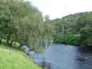
Learable Hill is situated
in the Strath of Kildonan, Sutherland.
the hill is rich in archaeology from many periods. Major sites
include clearance village, standing stones, hut circles, stone rows, cup
stones. Sings of agriculture are clear with a rigg system on the
hillside. the clearance village must have supported a sizeable
population as there are numerous foundations of houses and other buildings
alongside animal pens and boundary walls.
What's At Learable Hill
- Here are a few
Standing Stone with Cross incised
Map reference: NC 8925 2749
Stone Circle
Map reference: NC 8916 2351
Stone with Cup And Ring-Markings
Map reference NC82SE 5 8945 2402.
The Canmore database of RCAHMS indicates the stones may have been part of
a circle of standing stones
Stone Rows
Map references - NC 8924 2355 & NC 8932 2349
Hut-Circles - Enclosure - Banks - Small Cairns
Map reference NC 889 234
Hut-Circles - Burnt Mounds
Map reference NC 879 239
There are eight hut circles and two burnt mounds in the vicinity.
Learable Village and Head-Dyke
Map Reference NC 895 236
Twenty-four buildings are to be found as outlined by the remaining
foundations and walls of this the village of Learable
The rig farming method is clearly still to be seen with about ten hectares
of arable land now just grassy slope. Two corn drying kilns are
amongst the buildings. A ring dyke encloses the village area
extending to 40 hectares. A wide variety of archaeological remains
are within the boundary covering many periods. The farm of Learable was
listed as rented in documents from the 16th century onwards.
For more information consult the
Canmore
Database on the RHCMS web site.
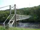
To reach Learable Hill cross the small Suspension Bridge over the
Helmsdale River and then the railway line. The fence has a style to
help you over. Take care to check for trains - not many but
still watch out. |
Learable Hill Full Picture Gallery
The pictures were taken by Bill Fernie on an
outing of Caithness Field Club on Sunday 8 August 2004
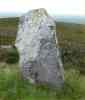
Standing Stone With Incised Cross
The standing stone easy to find on the hill.
The cross easy to see was probably added many hundreds of years after it
was placed
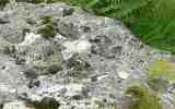
Stone With Cup and Ring Markings
The stone has a variety of cup markings and
indentations. the stone was probably once standing and may have been
part of a circle but only three stones remain. A fifty pence piece
was placed beside some of the cup markings to show the scale and make them
easier to see.
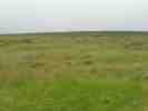
The grassy slopes are clearly part of a rig
system of agriculture and when you
are there you can distinguish the lines around the slope difficult to show
in the photograph at the time of day it was taken.
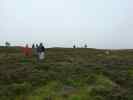
Checking out the Stone Rows |