N E W S F E E D S >>>
2004 Bulletin IndexBulletins Index

Caithness Field Club

Caithness Field Club Bulletin
2004

Achavanich - A Re-assessment
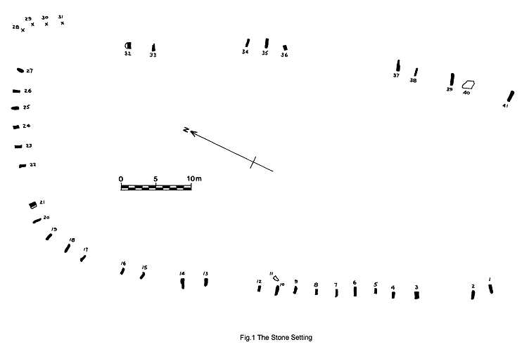
by Leslie J Myatt

Location of the Horseshoe Setting
1.5km along the road leading from the A9 at Achavanich to Lybster is a setting of standing stones whose name variously goes under the title of Achavanich, Achkinloch or Loch Stemster.

The names themselves are of some interest in that the first two are Gaelic in origin and the latter is Old Norse. According to Beaton (1909, 331) Achavanich seems to be the Gaelic Ach a' mhannaich, the Monk's Field. Achkinloch is The field at the head of the loch and Stemster derives from the Old Norse stein meaning stone with the familiar Caithness place name ending -ster indicating a homestead. Of the three names Stemster is the least used so as not to confuse it with the same name elsewhere in the county.

The site, at ND 1880 4178, is close to the road on the south side of Loch Stemster and the stones are set in the form of an irregular truncated oval, or horseshoe, and unusually pointing in towards the centre of the setting. Its axis lies NW-SE and it is open at the SE end where there is no evidence on the surface that it was ever fully enclosed. The two axes are approximately 69m and 31m; the latter widening towards the NW end. The setting is unusual in three particular aspects;

1. The stones point inwards. This feature, although uncommon, is however found to occur at the elliptical setting of Cnoc an Liath-Bhaid at Braegrudie, Strath Brora (NC 728 102) and at the ruinous setting of Clach an Righ, Dalharrold (NC 679 390), both in Sutherland; and also at Broubster (ND 047 608) in Caithness.

2. Whilst many stone settings conform to a geometrical shape of circular arcs that does not appear to be the case here, as the outline is somewhat irregular.

3. The shape is unusual in being a horseshoe and open at one end. There is one other example of this in Caithness and that is at Broubster (ND 047 608). Other examples are the trilithon horseshoe at Stonehenge and the horseshoe setting at Er-Lannic, Morbihan, Brittany which is now submerged by the sea at high water (Burl 1995,256).
Surveys of the Site

The first recorded survey of the site was made in 1871 by Sir Henry Dryden and R J Shearer. Later surveys were carried out by the author and the late Robert Gunn in 1974 and by Professor A Thom in 1981 (Thom, Thom and Burl 1990). All three surveys show exactly the same number of upright stones on the site. The plan shown in Fig.1 is based upon the survey of the author.

Early descriptions of the stones
Writing in 1774. (Pennant 1979, 334), the Reverend Alexander Pope, Minister of Reay, says;
'At the loch of Stemster, in this parish [Latheron], stands a famous Druidical temple. I have viewed the place: the circle is large, above 100 feet diameter; the stones are large and erect; and to shew that the planetary system was observed by them, they are set up in this manner, 1: 2: 3: 4: 5: 6: 7. Then the same course begins again; 1: 2: 3:

4: &c. Few of the stones are now fallen. Near the temple there is a ruin, where the Arch-Druid, it seems, resided. I find no such large Druid temples in the country; as for small ones, they are generally found in many places.'

In 1886 Dr Anderson writes (Anderson, 1886);
'It is in form of a long oval, somewhat irregular in outline and wider at one end than at the other. The two ends of the figure are also dissimilar in this respect, that, while the oval outline is complete at the wider end, the narrow end has been left incomplete and open. The stones are set with their broader faces at right angle to the direction of the lines , and not parallel to or in the plane of the lines........The length from the closed to the open end of the oval is 226 feet, and the width in the middle from one side to the other 110 feet inside measurement. At the open extremity the two sides are 65 feet apart. Supposing that the gaps have been occasioned by the removal or overthrow of some of the stones, they appear to have been set up at intervals of about 8 feet along the outline of the oval figure, but there is nothing to show why that form was preferred. There are now only thirty-six stones remaining in position, but if the gaps were filled at 8 feet intervals, the number would be fifty-four........the largest now standing being upwards of 5 feet above the ground, and others of less height measuring from 4 to 5 feet in breadth, and 12 to 10 inches in thickness. There is at the wide end of the oval a cist-like construction of four slabs, set in the ground, and abutting against one of the standing stones. It is not associated with the remains of a cairn; and beyond that it appears to be a cist, there is no actual evidence of its having contained a burial. Without this evidence it would be unscientific to attribute a sepulchral purpose to this unique variety of monument, and we must therefore be prepared to leave the questions of its age and purpose in abeyance until the evidence has been supplied by other examples of a similar type which may yet be discovered.'

The Setting Today
The setting of stones today appears as shown in the plan of Fig.1. There are a total of 41 stones which can be identified with 35 still standing in an upright position. Stones 11 and 40 are fallen and lying flat on the ground whist Nos. 28 - 31 appear to have slipped down the embankment on the northern corner. Stones 21 and 32 are leaning but appear to be in their original position. The present state of the setting with the number of stones upright and fallen is the same as shown in Dryden and Shearer's plan of 1871. On the outer periphery of stone 26 is a rectangular pit measuring 1.5 x 1.1m. It is stone lined on the sides and has the appearance of a burial cist which at some time has been excavated but of which there is no known record. Since it is shown on the plan of 1871 it must have been opened before that time. From surface evidence there may be similar cists on the outside of stones 18 and 37.

The ground falls away on each of the long sides if the setting with the road running close to the southwest. This road was described as 'new' on the 1871 plan. To the northwest the ground falls slowly whilst to the southeast there is a gradual rise.

Between the stones on the southwest side there is evidence of banking and it extends as far as the northwest part of the setting. There is however no evidence of this on the opposite side in the northeast. Only excavation would determine the nature of this banking but does it suggest evidence the setting having been an enclosure? This might explain why the stones were set pointing inwards to support the banking.

The grouping of the stones suggested by the Reverend Alexander Pope is difficult to understand since, apart from some grouping on the northeast side, which may be fortuitous, such groupings do not appear to exist.


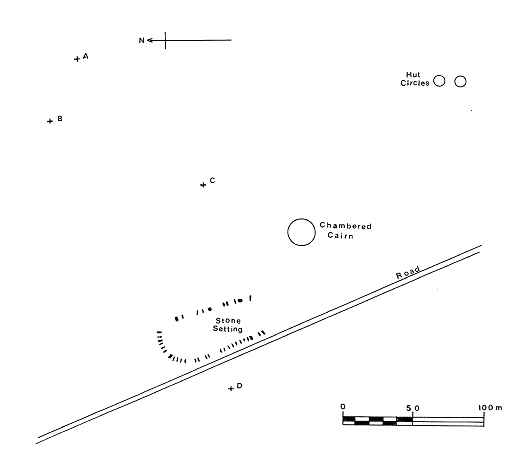
Fig 2 - The Surrounding Area

That the setting may have had astronomical significance is mentioned by Dr Euan MacKie (MacKie 1975, 223). Certainly the hills including Morven and Maiden Pap to the southwest and Ben Dorrery to the northwest would have provided ideal foresights for either solar or lunar observation.
Other Antiquities in the area
Within a short distance from the stone setting are a number of other antiquities. They are shown in the plan of Fig.2.

1. The Chambered Cairn
Whereas the stone setting probably dates from the Bronze Age in the second millennium BC, 70m to the southeast across a small burn are the remains of a much earlier Neolithic round chambered cairn (ND 1886 4170) of the Camster type (Henshall 1963, 257) (Davidson & Henshall 1991, 89). From radiocarbon dating evidence of other chambered cairns in the county this may date from as early as the fourth millennium B.C. It is an isolated cairn situated on a slight mound within rough pasture and is very ruinous with a diameter of about 25m. In the centre can be seen three upright slabs and from their position the entrance to the chamber was probably from the east.

2. Hut Circles
250m to the southeast of the stone setting, across two small burns and on a slight ridge, are two hut circles at ND 1897 4160 and at ND 1897 4159. The former has inside and outside diameters of the walling of 8.2m and 6.1m and a maximum height of 0.4m. The latter has similar walling diameters of 9.6m and 7.6m. In each case the entrance is in the west.
No radiocarbon dates are known for the hut circles in Caithness but it is possible that they could be contemporary with the stone setting.

3. Outlying Stones
There are four outlying standing stones as shown at A, B, C and D in Fig.2. Their grid references are as follows;
Stone A. ND 1898 4186 at an elevation of 159m.
Stone B, ND 1894 4188 at an elevation of 152m.
Stone C, ND 1886 4170 at an elevation of 150m.
Stone D, ND 1875 4175 at an elevation of 150m.
Stone A is square in section and leaning but firmly fixed in the ground. Its dimensions are 0.23 x 0.23 x 0.60m high.
Stone B measures 0.93 x 0.33 x 0.72m high. It is aligned on an azimuth of 307° true towards the hill of Dorrery.
Stone C just protrudes above the surface but is firmly fixed in the ground. It measures 0.15 x0.15x0.12m high.
Stone D is on the opposite side of the road to the main stone setting and lies fallen in boggy ground. It is partly buried in the peat but pointed at the end which is exposed. Its approximate dimensions are 0.2 x 0.7 x 1.8m long.

These outlying stones may have astronomical significance but this can only be determined by means of an accurate theodolite survey of possible alignments. There are good foresights to both the southwest in Morven and the adjoining peaks and also to the northwest in the hills of Dorrery and Beinn Freiceadain. All of these are quite distinctive on a clear day.

The Present State of the Site
The stone setting of Achavanich is visited by many people both resident in the county and summer visitors. It is the finest example of a stone setting on the northern mainland of Scotland with its unique horseshoe shape and is easy of access being next to the road. The land on which it is situated used to be grazed by sheep which kept the grass short. Now this does not appear to be the case and when visited during the summer the grass is in parts waist high. Visitors will undoubtedly want to go on to the site and the only access is over either the fence along the road or over a broken down gate as shown in the photograph below.

The site has an atmosphere of neglect and can only give a very poor impression to tourists. Visitors are encouraged to visit the site in local publicity. The Caithness Explorer Holiday Guide for 2003 states 'At Achavanich, near Lybster. there is a striking collection of stones which is becoming increasingly accessible to the public..... Public access to Achavanich is being improved with the creation of a small car-parking area near the stones.' Presumably this refers to the additional lay-by recently made on the side of the road up against the stones.

If we are to encourage visitors to visit our ancient monuments then something has to be done to present them to the public in a proper way. On one occasion during the summer of 2003 two bus-loads of people visited this site simultaneously almost blocking the road for the want of parking space despite the additional lay-by.

What is required at this site is,

  • An adequate parking area.
  • An agreement with the landowner for suitable gated access.
  • Annual maintenance of the site and grass cutting
  • An interpretive sign giving a plan and description of the stone setting and surrounding area.
    If we are to encourage visitors to see our sites of special interest they must be easily accessible, well cared for and presented in the best possible way.

References
Anderson J. 1886, Scotland in Pagan Times (Edinburgh)
Beaton D. 1909, Ecclesiastical History of Caithness (William Rae, Wick)
Burl A. 1995 A Guide to the Stone Circles of Britain Ireland and Brittany (Yale)
Davidson J.L. & Henshall A.S. 1991, The Chambered Cairns of Caithness (Edin. U.P.)
Henshall A.S. 1963, The Chambered Tombs of Scotland 1 (Edin.U.P.)
MacKie E. W. 1975, Scotland: An Archaeological Guide (Faber & Faber)
North of Scotland Newspapers 2003, Caithness Explorer
Pennant T. 1979, A Tour of Scotland in 1769 (Melven)
Thom A. Thom A.S. & Burl A. 1990, Stone Rows & Standing Stones Pt.ii (BAR)
© Leslie J Myatt 2003


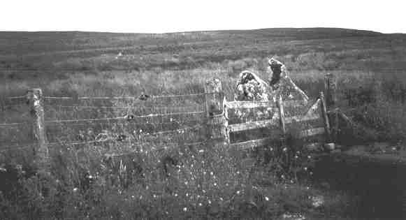
The broken entrance gate to the Achavanich stone setting

Achavanich In the Caithness.org A - Z

Bulletins Index