| N E W S F E E D S >>> |
|
Caithness Field Club Bulletin |
|
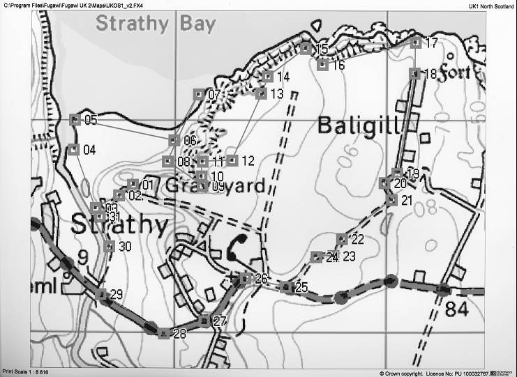
A Walk at Strathy and Baligill (by Ken Butler) This is a description of a walk taken by the Field Club on the 18th June 2006. It is an early summer walk of 4 ˝ miles over moderately rough country with some fences to cross. It took us 3 ˝ hours of gentle walking and it is mainly focussed on scenery, wild plants and geology. There is a GPS support file for those who have such a device, to help navigate the route. It is a circular walk, returning to the starting point. Ordnance Survey map references are given and points in square brackets such as [01] refer to the points on the map. The east side of Strathy Bay has rocky cliffs which are composed of Lower Old Red sandstone and associated conglomerates; it is known as the Baligill or Strathy Outlier since it is an isolated small patch not attached to the main sandstone mass of Caithness. It happens to be rich in calcium and other minerals, whereas the rocks of the surrounding area are hard and insoluble. Jack Saxon reviewed its geology in CFC Bulletin Vol 9 No 1 1991. Strathy Bay makes a deep indent in the coastline and it holds large quantities of calcareous sand, arising from this rock, which is blown by the wind to form a dune barrier behind which is a machair-type grassland. On the east side of the bay are rocky cliffs covered with a sandy turf. The Walk On the riverbank there are yellow-flowered Flag Iris and the trees are mostly Common Alder, which likes to be in a regularly wet place such as a river bank. Notice at the base of some trees the pink flowers of Pink Purslane, which is an introduction from Western North America, escaped from gardens. There are also Primroses and a Rowan Tree. Turn right and follow the river down to the sea [04]. Here notice the Wild Hyacinth or Bluebell in a mass on the slope of the bank across the river. Turn right and follow the top of the beach a little way then turn inland [05] up the sandy bank to get on a higher level of stabilised dune. Head east towards the grassy cliffs at the far end of the bay, walking through carpets of blue Germander’s Speedwell and yellow Birdsfoot Trefoil. There are occasional patches of Northern Marsh Orchid and Wild Thyme. On reaching the bottom of the grassy cliffs [06] (NC 84051 65893) the very rare alpine plant Purple Oxytropis (Oxytropis halleri) can be seen at several points, usually at the top of a rocky piece of cliff where the sheep cannot reach it. It has a purple clover-like flower and leaves which are divided into many opposite leaflets and are covered in silver hairs. Notice the steep grassy cliff slopes above, where the mineral-rich rock has eroded to enrich the soil. It is interesting to explore the rocks further out on the shore [07] where there are two sea caves and a wide crack through which a person can walk. Growing on the rocks is the alpine plant Roseroot with blue green leaves and small yellow flowers. Then walk inland along the base of the
grassy cliff to the gully [08] which has a path to the top of the cliff
[09]. Half way up the path turn to admire the view of Strathy Head and the
bay. Now walk on through strip fields which go back to the days (around 1815) when the ground was allocated to the crofters in long narrow strips with frequent rotation so that they all got a turn at the best soil. Head for an inlet, to be seen on the coast in the middle distance. Cross two fences to arrive at the inlet [13]. Continue round the coast until [15] a magnificent view opens up along the coast to the east and on the cliffs below are nesting seabirds. Climb up from here to the high point of the cliff [17] crossing a stile on the way. Here the severe storms have eroded the vegetation to a dwarfed sward of the hardiest plants. From here you can visit the fort a short distance down the hill or turn south to the end of the public road at Baligill [18]. The settlement of Baligill has three modern homesteads though there were clearly more in the past and there are many strip fields on either side of the road. Note the use of stone packing in the corner of the roofs at the tops of the walls in the derelict buildings. Walk along the road and turn right at the Y junction [19]. Follow the road, lined with Gorse, noticing a loch in the depression to the left which is surrounded by typical peat bog. Reach the junction with the main road [25] and turn right along the road. At this point stone has been quarried for the road. There is disused quarry on the right and a working quarry on the left. Notice the Golden Scaly Male Fern in clumps on the left side. Walk into Strathy, past the churches and down the hill. Gorse and Foxglove line the way. Pass the crossroads [27] and carry on past the roadside well (NC 84111 65019) and go down to the bridge over the Strathy river. Do not cross the bridge but go down to a gate on the right hand side which leads to the riverbank. Walk along the riverbank towards the sea looking out for the yellow-white flowers of the Lesser Butterfly Orchid and the crowds of Marsh Marigold in the muddy hollows. When you are past the farmhouse above and have crossed a small wooden bridge, the path [31] back up to the car park will be apparent. Walk up the hill to the car park through carpets of Cowslips. |
| The GPS Route The walk is made easier by using a GPS navigator set to show locations in UK Ordnance Survey references. The equivalence to the numbers in square brackets above is given below. |
|
Map Point |
O.S. Reference |
Comment |
|
01 |
NC838657 |
Car Park |
|
02 |
NC 83743 65642 |
|
|
03 |
NC 83628 65577 |
|
|
04 |
NC 83528 65857 |
|
|
05 |
NC 83528 65997 |
|
|
06 |
NC 84051 65893 |
Rare Flower Cliff |
|
07 |
NC 84113 66117 |
|
|
08 |
NC 83968 65802 |
|
|
09 |
NC 84138 65692 |
Top of Gully |
|
10 |
NC 84130 65731 |
|
|
11 |
NC 84138 65802 |
Fence climb point |
|
12 |
NC 84273 65805 |
|
|
13 |
NC 84408 66122 |
Inlet |
|
14 |
NC 84443 66202 |
|
|
15 |
NC 84623 66332 |
Viewpoint |
|
16 |
NC 84698 66262 |
|
|
17 |
NC 85138 66362 |
Top of cliff |
|
18 |
NC 85133 66217 |
End of road at gate |
|
19 |
NC 85048 65747 |
Y junction – turn right |
|
20 |
NC 84993 65702 |
|
|
21 |
NC 85028 65617 |
|
|
22 |
NC 84798 65437 |
|
|
23 |
NC 84753 65357 |
|
|
24 |
NC 84673 65352 |
|
|
25 |
NC 84533 65212 |
Main road – turn right |
|
26 |
NC 84338 65252 |
|
|
27 |
NC 84148 65047 |
|
|
28 |
NC 83953 64992 |
|
|
29 |
NC 83653 65172 |
Bridge gate on right |
|
30 |
NC 83693 65402 |
|
|
31 |
NC 83648 65542 |
Go up the hill |