| A Circular Tour of Old Wick (by Eleanor
Leishman)
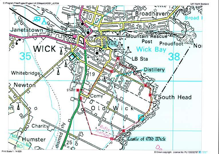
Try This Walk Yourself Print Version This is a record of a walk undertaken on 19th June 2007 by Field Club members, led by Eleanor. This walk includes points of historical interest around Auld Wick and upper Pulteneytown. The distance is approximately three-and-a-half miles and the walk takes about two-and-a-half hours. The terrain provides gentle walking along well-defined tracks, roads and town streets. Ordnance Survey map references are given at key points to help with navigation and a map is included. Park in the large car park beside Lidl's store in South Road (Pt “START” ND361498). The walk begins by crossing the main road (A99), turning right and walking south along the pavement towards a belt of trees. There is a signpost (Pt 2 ND361497) pointing along a grassy track leading through the trees, which indicates that the castle of Old Wick is one mile ahead. Follow this path, as it leads straight onto the Municipal and Police Burgh March. As you approach the Castle of Oldwick the path crosses the mill lade (Pt 3 ND368488), constructed between 1807 and 1809 by the renowned civil engineer Thomas Telford. This lade brought the first water supply to Wick from Hempriggs. Ahead of you across the geo is the Castle of Oldwick. It is considered to be the oldest Norse keep in Caithness, dating from the 12th Century, and was possibly built by the Norse Earl Harald Maddadorson, who was also Earl of Caithness. The fragmentary remains of a rampart and the gatehouse survive on the landward side of the ditch once crossed by means of a drawbridge. Four floors, marked by scarcement ledges, each held a single room beneath a pitched roof. A door at first-floor level on the seaward side gave access to the tower, but this has now collapsed. Access to the other floors must have been by wooden ladders, as there is no staircase within the walls. Two tiny windows on each floor provided the only internal light. The building is similar in design to another undated castle at Forse, Latheron. Both are recorded, together with Dirlot, as the property of the Norman de Chene family during the 14th century. The ownership of the Castle of Old Wick passed by marriage from the de Chene family to Lord Duffus, and in the 15th century to the Oliphants. It was besieged and the occupants starved into submission by John Sinclair in 1569, then sold to Campbell of Glenorchy in 1670. Owned by the Dunbars of Hempriggs until 1910, it is now in the care of Historic Scotland. Now turn left and follow the cliff path north towards Wick, passing between the rifle range and the targets/butts. Keep to the coastal track, but pause beside the wicket gate close to the sentry look-out shelter (Pt 4 ND370490). This is one of the best positions from which to see the rock face of the "Old Man of Wick". It is on the seaward facing headland of the furthest-out peninsula of the group at Old Wick. It displays a full-face and profile of a head. The local ditty states: "The Old Man of Wick was a man, Turn north once again and pass through the gate into the field beyond. Continue to walk straight ahead. To the right, towards the cliff edge, are the boulders called the Grey Bools. During the last ice age in Scotland 25,000 - 10,000 years ago the ice sheet in parts of the highlands was over 915m (3,000ft) thick. The predominant movement of the ice sheet was from south to north. The depth of the ice sheet over Caithness at this time was unknown. Ice was certainly thick enough to over-run Ben-a-Chielt, 287m (942ft), but there is no evidence that Morven, 706m (2313ft), was submerged. In its passage from the North Sea onto the Caithness land, the ice met with considerable obstacles in the steep landward approach from the sea, the high cliffs and the scarp faces along the east coast. Here on the South Head, a collection of local boulders was probably snapped off by the ice from the seaward-dipping sedimentary rocks and deposited in situ. Continue towards Wick Bay by crossing the stile beside the field gate. Immediately to the right is the (now blocked up) access road which led down to one of the South Head quarries. Because of their close proximity to Wick, these flagstone quarries were used to provide stone for the building of Pulteneytown. It is also one of the main reasons why Wick was chosen for development, rather than Staxigoe or Ackergill. The quarries were worked between 1820 and 1947. Further along one area known as the Trinkie is still in use today as an outdoor swimming pool. It is the trink (Norse) or trench left once the quarrying had finished. It is maintained by local historian Iain Sutherland and his group of workers called "Friends of the Trinkie". Follow the road for another 200 yards north to a point where there is a gentle incline and dog-leg bend (Pt 5 ND375497). At this point the road crosses above a large cave. The cave was periodically inhabited by four families of travelling people until the 1940s. They were believed by some to be descendants of the oldest of all Caithness races. They worked as tinsmiths who made milking/water pails, but they also sold dishes and bought old clothes and rags. In summer they travelled the county, living in tents, whilst seeking work on local farms. The introduction of enamel and later the arrival of Woolworth killed their trade, and many became unemployed. Carry on along the road as it snakes to the left towards Wick. The large building to the right on the clifftop (Pt 6 ND374499) is the old Royal Naval Reserve drill shed, built in 1876. It is a massive stone building sixty feet long and twenty five feet wide, at the end of which were rooms for the officer-in-charge, and naval stores. Detached from the main building is a small, solid and compact structure forming a magazine for powder. Later the main shed was used as the coastguard station, until it ceased operational use in 2001. The coastguards now have their base at Wick harbour, and this building has become a private dwelling. Twenty yards beyond the magazine take the track to the right along the clifftop. Another 200 yards along, pause and look to the bay for the flagstaff marking the seaward end of the Stevenson Breakwater. In 1863 the foundation stone was laid for a new harbour for Pulteneytown. The engineers were D&T Stevenson of Edinburgh. Satisfactory progress was made for a couple of years, then a storm occurred which breached part of the work. The breach was made good and the pier again extended. Successive years brought similar calamities, until 1873 when the fabric was damaged to such an extent that the work was abandoned. Upwards of Ł150,000 had been invested but the venture was a total loss. Continue for 200 yards along the path towards Wick until you reach the monument to James Bremner (1784-1856). A native of Keiss, he trained as an engineer in Greenock before setting up his own shipbuilding business in Wick. He built the outer harbour at Pulteneytown as well as the harbours of Keiss, Sarclet, Lossiemouth and Fraserburgh. His nickname of the "Wreck Raiser" was well deserved as he displayed considerable ingenuity and enterprise in raising and recovering 236 ships wrecked round the Scottish coast. Most notably he is remembered for raising the huge ship "SS Great Britain" when she foundered at Dundrum Bay in Ireland in 1847. Now look down to the shore just below the monument. You will see the old RNLI shed built in 1915 on the Salmon Rock, This building now serves as the boat shed for the Fifie fishing vessel "Isabella Fortuna" belonging to the Wick Society. To the left of the shed and below the cliff is the area known as Shaltigoe. In the 1860s this was the site of one of the largest curing-yards in Wick. It belonged to James More of Pulteneytown. The Scottish export trade of salted herring to Ireland and the slave plantations in the West Indies was immense, while after the Napoleonic Wars (post 1815) The European market flourished, with huge exports to the Baltic states, Eastern Europe, the German states and Russia. The herring boom lasted for over forty years, and brought about the development of Pulteneytown. Walk to the end of the track and cross the road into Bexley Terrace. You are now in Upper Pulteneytown. Proceed along this street and into Smith Terrace. On the right is the delightful little building called the Pilot House (Pt 7 ND369504). Built in 1908 it was the gift of Sir Arthur Bignold MP. It provided a base for the pilots who were responsible for guiding shipping in Wick Bay. From the Pilot House, cross the road and walk south into Huddart Street, continue across the junction with Kinnaird Street, and on towards the intersection with Barrogill Street (Pt 8 ND368502). The building immediately to the right is the Barrogill Mission Hall. In 1893 this hall was built under the direction of the fathers of the Wick Free Church on Bridge Street. They wanted it to be called "Wick Free Church Hall". However they had solicited financial support from all the local residents of Pulteneytown, and their loyalties were very much confined to Pulteney. When it became known that the word "Wick" would appear on a wall plaque, there was a threat of public disorder. Eventually the plaque was put in place above the main door, but to this day it bears no inscription. Continue to walk the length of Barrogill Street until you reach the junction with Macrae Street, The building across the road to the right was the old rope works. In 1819 rope and twine were produced here, and such was the demand that later developments saw four rope works in the area stretching from Macrae Street to Francis Street. They produced rope, twine, sails and nets. Turn left from Barrogill Street and walk along Macrae Street towards Harrow Hill, passing the Bignold Park on your right. In 1900 this park was gifted to the town by Sir Arthur Bignold MP. Next to the Bignold Park is the Harmsworth Park, Gifted by the Harmsworth family, it is the home of Wick Academy football club. The sole house on the right was once the Fever Hospital. Today it is a private dwelling house. Ten yards beyond the house, go through the gate on your right and into the cemetery itself. Originally known as Harrow Park, it was laid out in 1872 at a cost of Ł3,000. There is a carriage drive all round it, as well as intersecting walks, and it contains some beautiful monumental stones of historic interest. Walk the length of the cemetery along the carriage drive until you come to the caretaker's lodge. Pass through the gates then cross the South Road to return to the car park. |