| N E W S F E E D S >>> |
|
Caithness Field Club Bulletin |
| Strathmore Flora (Contributed by
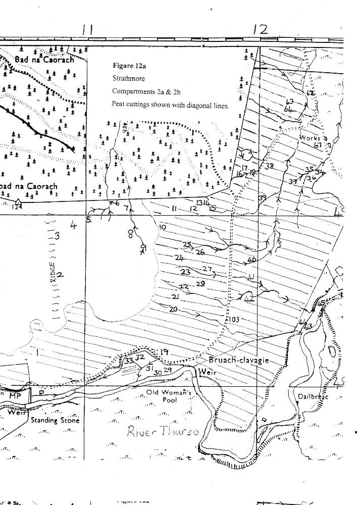
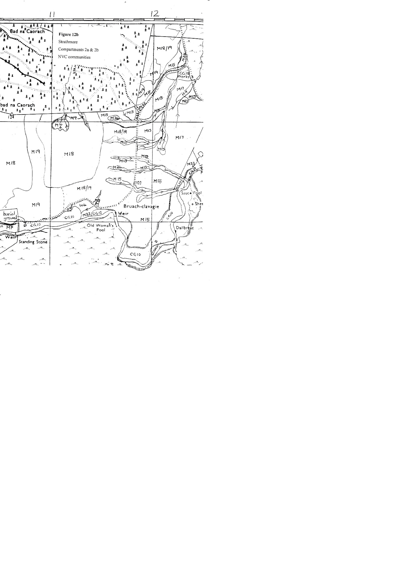
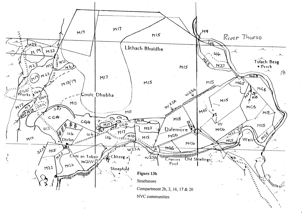
U. K. Gerry) (This article is part of a larger survey, including the Forsinard area, but only the Strathmore section was submitted.) 1.1.2 Strathmore The smaller area east of Strathmore Lodge is bounded by the River Thurso which also marks the northern boundary of the SSSI (Figure 11). The survey area starts from a line drawn from a burial ground beside the river east of Strathmore Lodge, up to a cairn on the south side of the forestry labelled on the map as Cnoc bad na Caorach (round wooded hill of the sheep) The northern boundary of the survey area follows the edge of the forestry and then cuts across to the east and just below Tormsdale before rejoining the river. It includes compartments 2A, 28, 3, 14, 15, 16, 17, 18, 79, 20 and 23. There are a few old cottages and two sets of farm buildings at Dirlot and Dalemore. Another set of buildings with the remains of turf dykes is still visible north east of Dalemore. Peat roads can still be traced going up the hill from these last two settlements. There are the remains of a castle at Dirlot beside the river, with an old burial ground. Stone rows in the nearby bog, hut circles and three brochs on the other side of the river indicate that this site has also been inhabited for many thousands of years. The geology of this area is very different from Forsinard. The underlying rocks are Middle Old Red Sandstone in the flagstone facies (Brown, 1981) The moraine was derived both from east flowing glaciers and also from an intervening glacier which flowed into the Moray Firth but was deflected by Scandinavian ice to flow north across the sea bed. This ice picked up shelly material and other rocks which were deposited across Caithness (Johnstone & Mykura, 1989). This has provided a calcareous source which leaches out in some flushes. The whole area is also patchily overlaid by fluvio-glacial outwash part of which formed a very notable ridge that has largely been quarried away. The ridge formerly started from near the tarmac road and ran past Dirlot farm almost as far as Dalemore and was probably an esker deposited by sediment-laden water flowing through a tunnel in the ice. Thick deposits of peat exposed in the old quarry show birch and pine remains similar to those seen at Forsinard. 1.2.2 Strathmore The Strathmore site has also been cut for peat with a very large area cut back from the road north and east of the Strathmore Lodge burial ground. The east side of the tarmac road towards Dirlot has also been almost all cut over at one time. In some instances the mire looks level but faint traces of a slightly different vegetation indicate the position of the access paths between the cuttings, as in the mire north west of the Dirlot cottages. Peat was also cut in long strips up the east side of the hill, Lathach Bhuidhe, north of Dalemore. The fields near the river at Dirlot and Dalemore have presumably long since been stripped. These fields have been sown with rye grass and have been improved, but the heavily grazed fields north and east of Dalemore still have the remnants of a mire vegetation. The grassland on the lowest river terrace is assumed to be derived from locally occurring species. The notable ridge of sand and gravel has been a barrier to peat cutting on the hill behind. This has protected a flat area and the gentle slope up to the flat top of the hill before meeting the cut areas from the Tormsdale side. In such an intensively cut-over area this uncut part is of especial interest and value. The ridge itself has been almost entirely quarried away. The quarry has operated over more than fifty years, although extraction has not been continuous. Water was pumped from the River Thurso to wash the sand and the outflow (after complaints from fishermen) was allowed to stand in settling ponds before flowing down the Allt an Ruathair back to the river (pers. comm. U. K. Gerry). A wide fan immediately down slope of the quarry was flushed with slightly enriched water and the original vegetation is overgrown by another community in response to the eutrophication. The water has flowed over a series of peat cuttings extending in from the road in the west. The uncut surfaces above the level of the flushed water retain the original more acidic vegetation. Moraine has survived on the west side of the track past the quarry and now makes a heathy ridge. Small-scale quarrying in the angle of the tarmac road and the Dirlot track has left hummocks and mounds. Flushing from the forestry only appears to have affected the north west corner of this area as the forestry is mostly down slope. There is, however flushing into peat cuttings on sloping ground where they have been excavated deeply. This is emanating from the underlying moraine and has glven rise to unusual communities in close proximity to one another. 1.3 Objectives The survey was designed to provide detailed maps showing the National Vegetation Classification (NVC) as closely as this can be correlated with communities which are an unusual combination of species due to anthropogenic and natural effects and which are growing at the north end of the range of NVC communities. 2. Methods 2.1 Quadrat selection A total of 151 and 111 2 x2 m quadrats were sampled from Forsinard and Strathmore respectively. The percent cover of vascular plants and bryophytes was recorded. Quadrats were placed to give a good coverage of the perceived types of vegetation so that more samples were taken in areas of greater variation and fewer in homogenous stands. Most samples were taken in recognisable blocks of similar vegetation. More samples were taken at the beginning of the survey. Later mapping was done with notes to relate the vegetation types to those which had already been sampled. Occasional samples were taken outside the survey area where the boundary was not clear on the ground. The location of each quadrat was taken with a Garmin GPS 76 Marine Navigator. 2.2 Classification These data were grouped into different National Vegetation Classification types using ComKey. This programme has a variety of possible methods for comparing the species present in the samples with the type communities defined in the NVC (Rodwell, 1995, 1998a, 1998b, 1998c, 2000). A combination of these was used to determine an appropriate community. With the weighted species match, species are weighted according to the indicator value of each species which is derived from all the species recorded in the NVC communities divided by the number of communities in which the species occur. The analysis gives a score out of 100, the matching coefficient, which indicates how many of the species in the sample are present in different NVC communities. This method only gives weighting to the species which are present and is not influenced by those that are in the NVC type communities but absent in the sample. Also used was a presence-weighted match which takes account of the percent cover of each species, not merely its presence or absence. Different methods provide slightly different answers but the different methods were compared and the most appropriate communities were selected. In some areas several communities seemed almost equally appropriate, reflecting relics of past vegetation and elements of new communities encouraged by flushing which could become dominant eventually. The community was finally selected by taking into consideration other samples in similar adjacent vegetation. The range of possible communities is described in the text for each site. 2.3 Drawing the maps The maps are a combination of boundaries identified in the field, clarified by the use of the 19xx air photographs. Where a distinction can be made between different types of vegetation, a solid line is drawn. Where there is a gradual gradation the approximate boundary is shown with a dotted line. When there is extensive flushing from the forestry nearly half the slope is a different vegetation type. If this is a small scale mosaic with the flushing in depressions or around hillocks any elevated ground is not flushed. This is indicated by showing both vegetation types separated by a forward slash. Figure 1 shows all the compartments surveyed on the Forsinard site with Figures 2 - 10 showing different compartments of the site from north to south. Figure 11 shows the whole of the Strathmore site including the compartments with Figures 12 - 13 showing the west and east of the site to scale. The vegetation maps are all at a scale of 1: 1 0 000 except for Figure 10 which is 1:5 000. Each compartment has two maps. The first (a) shows the quadrat locations, rivers, drains and any peat cutting indicated by diagonal lines. The second (b) shows the communities. 3. Results 3. 1. Matching co-efficients Two sets of matching co-efflcients are given in Appendix 1 and 2 for the Forsinard and Strathmore sites respectively. The selected communities are highlighted in bold. There is an inconsistent correlation for sub-communities and these are not usually given unless one is especially descriptive. The communities for both sites are listed in Appendix 3. Appendices 4 and 5 give a list of the species that were found in the quadrats at the two sites and list the number of quadrats in which they appeared. 3.2.2 Vegetation communities at Strathmore 3.2.2.1 Mires and a swamp This site has not been described in compartments as the divisions cut across many of the vegetation boundaries. A ridge runs along the approximate western boundary of the survey area (Figures 12a and 12b). This gives a slightly drier elevation so that the vegetation has affinities to M19 Calluna vulgaris-Eriophorum vaginatum blanket mire but with correlations also to M15 Scirpus cespitosus-Erica tetralix wet heath, M17 Scirpus cespitosus-Eriophorum vaginatum blanket mire and M18 Erica tetralix-Sphagnum papillosum raised and blanket mire. These four communities characterise much of the mires in this area. The main part of the peat cuttings have a linear mosaic of M19 on the drier blocks that have not been cut, with regeneration of M18 in the unflushed cuttings. However, a considerable amount of flushing is seeping into the cuttings, especially on the lower slopes nearer the road. This flushing gives varying communities. Shallower cuttings and those towards the west are more acidic and have at most M15 Scirpus cespitosus-Erica tetralix wet heath. Several flushes produce a community that correlates with M10 Carex dioica-Pinguicula vulgaris mire although as the flushes progress towards the main burn they soon classify as M15. M24 Molinia caerulea-Cirsium dissectum fen-meadow is a very frequent alternative possibility for these M10 flushes despite the absence of C. dissectum. M11 Carex demisso-Saxfraga aizoides mire and M13 Schoenus nigricans-Juncus subnodulosus mire are other communities that frequently appear in the classification, but again have several species absent and are less appropriate. Northwest of this block of peat cuttings the original surface crests the slope and declines to a basin which mostly classifies as M18 Erica tetralix-sphagnum papillosum raised and blanket mire but still with correlations for M15, M17 and M19. Vaccinium microcarpum is frequent and there is a mixture of Dryopteris dilatata, D. cartlrusiana and possible D. expansa. These ferns are moderately frequent in this hollow, near the forestry to the north and in the flushed area below the quarry, but nowhere else on the part of the reserve surveyed. Runnels from the basin drain northwards into the forestry block. One area correlates with M6 Carex echinata-Sphagnum recurvum/auriculatum mire progressing through M9 Carex rostrata-Calliergon cuspidatum/giganteum mire and on through the forest fence. Another wet hollow nearby also correlates with M9 although all have some correlation also with M15 Scirpus cespitosus-Erica tetralix wet heath. There is a complicated mosaic of vegetation types where the northernmost peat cuttings are beside the edge of the forestry. A drain comes from the forestry and brings some flushing. There is presumably also some flushing from the underlying moraine. The overall classification is M15 Scirpus cespitosus-Erica tetralix wet heath but there are some areas with no peat visible and dense Juntcus effusus and J. conglomeratus. Salix repens grows here too. Swamping cushions of Polytrichum commune suggest forestry flushing and yet there are some flushes with short vegetation suggesting a strong calcareous input. CG11 Festuca ovina-Agrostis capillaris-Alchemilla alpina grass heath has a good correlation, except there is no Alchemilla. M24 Molinia caerulea-Cirsium dissectum fen-meadow correlates most frequently, repeating the occurrence of this community in the classification. The edge of the track from the forestry has M23 Juncus effusus/acutiflorus-Galium palustre rush pasture derived from the flushing and disturbance associated with the forestry. Heading north between the forestry and the tarmac road there is an area of M15, which is part of the forestry eutrophication, with islands of M19 Calluna vulgaris-Eriophorum vaginatum blanket mire on higher mounds or on uncut peat. Further north against the forest fence is an unflushed mosaic of M18/M19 between cut and uncut peat. South-east of this area the peat beside the road has been completely stripped and there is flushing from the forestry with a burn flowing from the flushed peat cuttings. The forestry flushing approximates to M15 Scirpus cespitosus-Erica tetralix wet heath but the area in the bend of the road has a better correlation with M24 Molinia caerulea-Cirsium dissectum fen-meadow with the alternatives of M25 Molinia caerulea-Potentilla erecta mire, CG10 Festuca ovina-Agrostis capillaris-Thymus praecox grassland or M13 Schoenus nigricans-Juncus subnodulosus mire. There is a large triangular area of mire between the tarmac road and the track to Dirlot. The extreme north end has hummocks and hollows and disturbed ground as if there has been small-scale quarrying. This is very mixed with rough grassland and some Calluna but CG10 Festuca ovina-Agrostis capillaris-Thymus praecox grassland has a reasonable correlation with U5 Nardus stricta-Galium saxatile grassland as another possibility. Further south all but a few hummocks, presumably of moraine, have been cut for peat. Most of the cuttings are shallow and in some instances only a softer texture and an increase in Scirpus cespitosus indicates the presence of former access paths along the top of uncut peat. There are flushed areas where runnels pass through from the peat cuttings on the slope across the tarmac road to the west. These correlate with M15 Scirpus cespitosus-Erica tetralix wet heath with M6 Carex echinata-Sphagnum recurvum/auriculatum as another possibility. There is a good population of Salix repens growing strongly from the burnt Calluna by the tarmac road. M17 Scirpus cespitosus-Eriophorum vaginatum blanket mire has been selected as the most likely community over most of this area, but M15, M18 and M19 all appear in the classification. Much of the area has been burnt quite recently, but the wettest areas and the runnels have not been affected. Further south, the Calluna is grazed very short and the ground is drier on both sides of a fence. Beyond the fence this community extends onto a terrace above a loop in the river. The peat thins and this might be natural although it is probable that it has all been stripped. The community is best classified as M15 Scirpus cespitosus-Erica tetralix wet heath but M19 and M18 are also a possibility. The sand and gravel quarry (Figures 13a & 13b) has occasional relics of the blanket mire and heath that presumably covered it before it was dug away. There are some large deep peat banks suggesting the infill of a hollow. One area has been left isolated by quarrying on all sides, but still remains an intact bog with retaining banks all around. It classifies as M17 Scirpus cespitosus-Eriophorum vaginatum blanket mire. There is an area of intact bog north and east of the sand and gravel quarry with M17 Scirpus cespitosus-Eriophorum vaginatum blanket mire although the classification also suggests M18 Erica tetralix-Sphagnum papillosum raised and blanket mire. This part of the bog has mounds of Sphagnum sometimes S. imbricatum (now austinii) but also other commoner sphagna. There is abundant S. magellanicum which is less frequent elsewhere. This area steps down into peat cuttings extending in from the north-west. There is a mixture of M15 Scirpus cespitosus-Erica tetralix wet heath within the cuttings and M19 Calluna vulgaris-Eriophorum vaginatum mire in the uncut areas. Further down the slope to the west has been flushed by the water that has come from the quarry. This has had a large effect over a wide area. Islands of Calluna above the level of the flushing show up as patches of M19 but the old cuttings, often with Sphagnum papillosum, have been overgrown by a new vegetation including S. palustre that generally classifies as M23 Juncus effusus/acutiflorus-Galium palustre rush pasture. There are several rapidly expanding clumps of willow, Salix aurita and tall S. Repens (> 1m) that have not been grazed. W4 Betula pubescens-Molinia caerulea woodland frequently appears in the classification in samples that correlate both with W4 and M6 Carex echinata-Sphagnum recurvum/auriculatum mire. Dryopteris carthusiana and D. dilatata occur once more. There is a mosaic of vegetation types, some denser and taller than others, probably relating to different depths of peat cutting and possibly with additional sources of flushing from the moraine. The woodland theme is extended with the presence of a lush stand of 60 cm tall Equisetum sylvaticum among the Juncus. Passing eastward from the flushed cuttings the uncut M17 Scirpus cespitosus-Eriophorum vaginatum blanket mire vegetation is on the plateau and rising hill above. The top of the hill is flatter with more lichens than most of the other sites. There are large prominent tussocks of Eriophorum vaginatum and a few mounds of mosses, but S. imbricatum is not on the flat top. The mounds are frequently overgrown with Racomitrium lanuginosum and one on the down slope even had Epilobium angustifolium growing on it. The east slope of the hill has been extensively cut for peat and is mostly M15 Scirpus cespitosus-Erica tetralix wet heath. The variety of alternative classifications illustrate the rapid alternation of different communities within the cuttings; W4 Betula pubescens-Molinia caerulea woodland, U5 Nardus stricta-Galium saxatile grassland, M6 Carex echinata-Sphagnum recurvum/auriculatum mire, M7 Carex curta-Sphagnum russowii mire, M17 Scirpus cespitosus-Eriophorum vaginatum blanket mire, and M19 Calluna vulgaris-Eriophorum vaginatum mire which are all possible correlations. On the south-facing slope of the hill the fields behind Dalemore have been almost completely stripped of peat although remnants of the cuttings can still be seen. A substantial turf dyke with a strip of gorse bushes approximating to W23A Ulex europaeus-Rubus fruticosus scrub marks the boundary between the hill and the fields around Dalemore. The grazed fields are Ml5 with short Calluna but some Sphagna are still present. There are two more similar M15 fields nearer the river but the other fields have been improved. A small field to the south west of the Dirlot buildings classifies as M15 where it has the appearance of an enclosed part of the bog which is actively regenerating with a high percentage of Sphagnum. Further south the field all round a ruined cottage is overgrown with rushes and correlates with M23. A small field of M23 Juncus effusus/acutiflorus-Galium palustre rush pasture immediately behind the Dalemore buildings is densely overgrown with Juncus and Rumex. Other small areas of M23 are found at the edges of fields or in the quarry. There is a triangular area of M17 Scirpus cespitosus-Eriophorum vaginatum blanket mire with a suggestion also of M15 Scirpus cespitosus-Erica tetralix wet heath or M18 Erica tetralix-Sphagnum papillosum raised and blanket mire that has survived between the track to Dalemore and the quarry. The peat cuttings into the edge of this area have bracken growing over them. This area classifies as M23 and the bracken is on the better drained ridges of peat. The gorse across the road and along by the river classifies as W23A Ulex europaeus-Rubus fruticosus scrub; The shallow channels within the quarry have M9 Carex rostrata-Calliergon cuspidatum/giganteum mire which also occurs on the east of the site near the river. The deeper ditches, pools and a canal within the quarry used as a settling pond classify as S27 Carex rostrota-Potentilla palustris tall-herb fen. There are other examples of this community east of Dalemore and west of Dirlot in dammed drains. 3.2.2.2 Other communities – grassland, heath and woodland The grass fields are assumed to be on areas which have had the peat totally removed, although some of the fields around Dalemore are on the lowest river terrace and might have been cleared by reworking of the river bed. The Dirlot fields are mostly on a slope and there is M15 at the top of one field but the grass on others is being reinvaded by M23 Juncus effusus/acutiflorus-Galium palustre rush pasture. Grass has been sown on improved fields around Dirlot and Dalemore. These fields generally correlate with MG6 Lolium perenne-Cynosurus cristatus grassland. There are narrow strips of MG5 Cynosurus cristatus-Centaurea nigra grassland by the river on the south east. M23 is spreading across the area near the bridge. Further north-east the riverside grassland has a better correlation with U4 Festuca ovina-Agrostis capillaris-Galium saxatile grassland, and once more M23 is spreading from the wet area in the old loop of the river. The higher fields around Dirlot correlate with U4 Festuca ovina-Agrostis capiIIaris-Galium saxatile grassland. Starting from Dirlot on the west side of the track there is a ridge of moraine extending half way along the track back to the tarmac road. This classifies as H12C Calluna vulgaris-Vaccinium myrtillus heath best described in the Galium saxatile-Festuca ovina subcommunity but has a good correlation also with CG10. Within the quarry there is a complicated mosaic of bare ground, with the SD16 Salix repens-Holcus lanatus dune slack community giving a strong correlation, but CGl0 Festuca ovina-Agrostis capillaris-Thymus praecox grassland better describes the other samples of colonising vegetation on open ground. U4 Festuca ovina-Agrostis capillaris-Galium saxatile grassland and U5 Nardus stricta-Galium saxatile grassland also feature in the classification as possible alternatives. There are still abundant heathy fragments on slumped slopes from the vegetation that grew over the moraine. Salix aurita was beginning to grow in one hollow and Festuca vivipara was found near quadrat 94. There were toads in the pools. Some of the pools had Lythrum portula. The riverbank west of Dirlot has grassland that does not appear to have been improved. From the Strathmore Lodge burial ground eastwards the bank is usually CG10 Festuca ovina-Agrostis capillaris-Thymus praecox grassland with U4 Festuca ovina-Agrostis capillaris-Galium saxatile grassland on the steeper banks up to the road and frequently on the verge too unless it is CG10 again. There are patches of Pteridium aquilinum with a reduction in the species present beneath the canopy, but usually the same classification. There are occasional patches of Calluna on terraces near the road, classifying as H12C Calluna vulgaris-Vaccinium myrtillus in the Galium saxatile-Festuca ovina subcommunity. The wetter areas by the river are rushy and classify as M23 Juncus effusus/acutiflorus-Galium palustre rush pasture. East of the weir and along the big bend in the river going east to Dirlot, there is a wide flat river terrace grazed by sheep. Again this has some correlation with CG10 Festuca ovina-Agrostis capillaris-Thymus praecox grassland with U4 and U5 additional possibilities. At least half of this lower terrace and much of the slope up beneath the Dirlot burial ground is covered in bracken. This is sparser than might be expected as it was sprayed recently to facilitate fishing access to the Thurso River (pers. comm. A. P. Gerry). The vegetation beneath the bracken classifies as CG10 but also has a strong correlation with U4 Festuca ovina-Agrostis capillaris-Galium saxatile grassland and even W11 Quercus petraea-Betula pubescens-Oxalis acetosella woodland. There are a few trees, Prunus padus and Sorbus aucuparia, on the cliffs in the ravine where they are protected from grazing. There are some large sycamore trees planted around Dalemore and a small plantation of conifers near the Dirlot cottages. 4.2 Strathmore Many of the same communities are also are found at Strathmore but being further east this location is sufficiently far removed from the Forsinard area to show significant differences in the vegetation. Unfortunately, correlation coefficients are more difficult to interpret as they are even less definite. The upland community of M19 Calluna vulgaris-Eriophorum vaginatum blanket mire frequently features in the classification. As a community which shows signs of erosion M19 is appropriate for the ridge on the west of the survey area and for isolated remnants of peat where the rest has been cut away. The presence of Dryopteris ferns indicate open areas available for colonisation as in eroded patches and the edge of peat cuttings. M18 Erica tetralix-Sphagnum papillosum raised and blanket mire on the westernmost uncut area is confirmed by the presence of Vaccinium microcarpum, although this is also growing into an old cutting on the east side of this area. M18 Erica tetralix-Sphagnum papillosum raised and blanket mire is determined by a higher proportion of Sphagnum than M17 and there is also less Scirpus. The other uncut mire the Cnuic Dhubha, which was protected from cutting by the ridge of moraine, could also possibly be M18, the coefficients are not as clear-cut as would be desirable. The east side of the hill above this bog is named L�thach Bhuidhe suggesting it once had a more yellow appearance which might have related to a higher proportion of Scirpus in M17. The cut-over slope now correlates with M15 Scirpus cespitosus-Erica tetralix wet heath and has a patchwork of greener vegetation and very little Scirpus. M18 Erica tetralix-Sphagnum papillosum raised and blanket mire is less frequent on the Forsinard Reserve generally as M17 Scirpus cespitosus-Eriophorum vaginatum blanket mire is more typical of an uncut surface. As at Forsinard, there are some species that do not grow so far north which are constant species in the NVC communities. M22 Juncus subnodulosus-Cirsium palustre fen-meadow which frequently appears in the classification but is based on J. subnodulosus which does not occur north of the border. The other species do match reasonably well and this community is still a possibility for communities which have mostly been assigned to M23 Juncus effusus/acutiflorus-Galium palustre rush pasture instead. M24 Molinia caerulea-Cirsium dissectum fen-meadow is another apparently southern community which frequently has a good correlation and has been selected for cut over one area beside the tarmac road and a flush in peat cuttings near the forestry. These two areas receive both flushed water from the forestry and also water draining from the cuttings which might also be flushed from the underlying moraine. M24 is a transition community and is appropriately a secondary community derived from different origins (Rodwell, 1998b). As a community it is associated with the warmer south of Britain, but possibly these areas are especially sheltered. Grazing is important in maintaining this community and the rich variety of species will help to attract animals. MG5 Cynosurus cristatus-Centaurea nigra grassland has survived in a few places at the edges of fields near the river at Dalemore. These marginal areas have not been improved and are more species-rich than the sown MG6 Lolium perenne-Cynosurus cristatus grassland in the fields nearby. U4 Festuca ovina-Agrostis capillaris-Galium saxatile grassland is also present near the river and around Dirlot on more acidic, leached, unimproved land which does not receive any flushing. There are occasional clumps of Calluna, which either indicate the heathy origin of the grassland or suggests that it is reverting. The CGl0 Festuca ovina-Agrostis capillaris-Thymus praecox grassland is by the rivers, a typical habitat where the riverside gravel provides drainage and the flood plain can receive additional silt and nutrients (Rodwell, 1998c). There will also be some flushing as water from higher ground seeps through to the river. W4 Betula pubescens-Molinia caerulea woodland is a possible development on the irrigated fan down slope from the Quarry. While short Salix repens is found in old peat cuttings and on the south part of the hill behind Dalemore, it is only in the area below the quarry that shrubby growth is well advanced. There is no sign of Betula, and the nearest seed source must be some distance away, but the willows appear to be growing vigorously and this area seems to be sufficiently ungrazed, for the expansion of shrubs. There are broad strips of W23A Ulex europaeus-Rubus fruticosus scrub both by the river and over a substantial turf dyke which divides the field around Dalemore from the hill behind. Growing vigorously, there is little undergrowth and the stands do not appear to have other species which might progress to woodland. It was noticed that Juncus conglomeratus is unusually frequent at Strathmore compared with J. effusus, being present in l8 and 29 quadrats respectively. When compared with 6 and 26 quadrats respectively at Forsinard this illustrates the generally wetter climate further west. A similar pattern is seen in the 16 quadrats out of 111 that have Scirpus at Strathmore, compared with 55 out of 151 at Forsinard. Plantago maritima occurred in flushes at quadrat 26 but also by the road as elsewhere at Strathmore and indeed throughout the north of Scotland. Several of the communities had an unexpected combination of species which did not classify satisfactorily. 5 Appendix Species at Strathmore and the number of quadrants in which they were present . Aclillea millefolium 6 Achillea ptarmica 10 Agrostis canina 26 Agrostis capillaris 19 Agrostis stolonifera 4 Aira praecox 1 Alopecurus geniculatus 1 Anthoxanthum odoratum 21 Aphanes sp. 1 Arrhenatherum eIatius 1 Athyrium filix-femina 1 Aulacomnium palustre 21 Bellis perennis 5 Calliergon cuspidatum 4 Calliergon stramineum 4 CalIitriche seedling/sp 1 Callitriche stagnalis 1 Calluna vulgaris 49 Caltha palustris 3 Calypogeia fissa 1 CaIypogeia mueIIeriana 2 Cardamine flexuosa 1 Cardamine pratensis 6 Carex binervis 2 Carex demissa 2 Carex dioica 2 Carex echinata 17 Carex fIacca 6 Carex hostiana 8 Carex lepidocarpa 1 Carex limosa 1 Carex nigra 23 Carex ovalis 2 Carex panacea 16 Carex pilulifera 2 Carex pulicaris 5 Carex rostrata 7 Cerastium fontanum 14 Cirsium palustre 25 Cirsium vulgare 1 Cladonia arbuscula 3 Cladonia portentosa 24 Cladonia uncialis 7 Climacium dendroides 1 Conopodium majus 1 Cornicularia sp 2 Cratoneuron commutatum 1 Cynosurus cristatus 5 Dactylorhiza maculate 4 ericetorum Danthonia decumbens 3 Deschampsia c. Cespitosa 21 Deschampsia flexuosa 22 Dicranum scoparium 8 Digitalis purpurea 1 Drepanocladus revolvens 2 Drosera anglica 4 Drosera rotundifolia 19 Dryopteris carthusiana 2 Dryopteris dilatata 10 Dryopteris expansa 1 Empetrum nigrum nigrum 16 Epilobium brunnescens 1 Epilobium palustre 7 Equisetum arvense 5 Equisetum fluviatile 13 Equisetum palustre 23 Equisetum sylvaticum 1 Erica cinerea 1 Erica tetralix 42 Eriophorum angustifolium 27 Eriophorum vaginatum 35 Euphrasia officinalis agg 3 Eurhynchiurn speciosum 1 Festuca ovina 8 Festuca rubra 6 Filipendula ulmaria 1 Fissidens adianthoides 2 Galium palustre 11 Galium saxatile 14 Galium verum 1 Glyceria fluitans 1 Hippuris vulgaris 2 Holcus lanatus 47 Hydrocotyle vulgaris 1 Hylocomium splendens 39 Hypnum cupressiforme 1 Hypnum jutlandicum 27 Iris pseudacorus 3 Isolepis setacea 1 Juncus acutiflorus 5 Juncus articulates 15 Juncus bulbosus 4 Juncus conglomeratus 18 Juncus effusus 29 Juncus squarrosus 13 Jungermannia exertifolia var. 1 cordifolia Lathyrus pratensis 4 Leontodon autumnalis 4 Leucobryum glaucum 1 Linum catharticum 2 Listera cordata 1 Lolium perenne 5 Lophozia ventricosa 2 Lotus corniculatus 3 Luzula multiflora 28 Lychnis flos-cuculi 1 Lythrum portula 1 Menyanthes trifoliate 3 Mnium hornum 1 Molinia caerulea 28 Mylia taylorii 1 Myosotis discolour 1 Myosotis scorpioides 3 Nardia scalaris 1 Nardus stricta 16 Narthecium ossifragum 21 Odontoschisma sphagna 8 Pedicularis sylvatica 5 Peltigera caninu 4 Philonotis Fontana 2 Phleunm pratense 1 Pinguicula vulgaris 3 Plagiomnium elatunt 1 Plagiomnium undulatum 4 PIagiothecium undulatum 8 Plantago lanceolata 2 Plantago maritima 1 Pleurozia purpurea 2 Pleurozium schreberi 28 Poa annua 1 Poa pratensis 4 Poa trivialis 1 Pogonatum urnigerum 1 Polygala serpyllifolia 2 Polytrichum commune 13 Polytrichum juniperinum 3 Potamogeton polygonifolius 5 Potentilla erecta 38 Potentilla palustris 10 Prunella vulgaris 8 Pseudoscleropodium purum 18 Pteridium aquilinum 4 Racomitrium Ianuginosum 6 Ranunculus acris 13 Ranunculus flammula 11 Ranunculus repens 4 Rhinanthus minor 1 Rhizomnium punctatum 1 Rhytidiadelphus loreus 12 Rhytidiadelphus squarrosus 17 Rhytidiadelphus triquetrus 4 Rumex acetosa 17 Rumex acetosella 3 Rumex obtusifolius 1 Sagina procumbens 1 Salix aurita 1 Salix repens agg. 7 Scirpus cespitosus 16 Selaginella selaginoides 1 Sparganium erectum 2 Sphagnum auriculatum var. 35 auriculatum Sphagnum capiIIifolium 6 Sphagnum cuspidatum 1 Sphagnum fimbriatum 2 Sphagnum magellanicum 2 Sphagnum palustre 19 Sphagnum papillosum 27 Sphagnum recurvum 23 Sphagnum russowii 1 Sphagnum squarrosum 2 Sphagnum subnitens 7 Sphagnum tenellum 2 Stellaria alsine 4 Stellaria graminea 1 Stellaria media 2 Succisa pratensis 6 Taraxacum officinale agg. 1 Thuidium tamariscinum 2 Trifolium repens 12 Triglochin palustre 1 Ulex europaeus 1 Vaccinium microcarpum 5 Veronica chamaedrys 1 Viola palustris 11 Viola riviniana 2 6. Figures Fig12a Strathmore compartments 2a and 2b Fig12b Strathmore compartments 2a and 2b - NVC communities Fig13a Strathmore compartments 2b 3 16 17 & 20 Fig13b Strathmore compartments 2b 3 16 17 & 20 NVC communities 7. References Brown, G. M. (1981) Caithness l:250 000 Series. Institute of Geological Sciences, Ordnance Survey, Southampton. Carey, P. D. & Dines, T. D.(2002). New Atlas of the British and lrish Flora. Eds. Preston, C. D. Pearman, D. A. & Dines, T. D. Oxford University Press, Oxford. p841 Johnstone, G. S. & and Mykura, W. (1989). The Northern Highlands of Scotland. British Geological Survey. HMSO. London. Ordnance Survey (1973) Place names on maps of Scotland and Wales. Director General of the Ordnance Survey, Southampton. Porter, M. S. & Foley, M.J.Y. (20A4. New Atlos of the British and lrish Flora. Eds. Preston, C. D. Pearman, D. A. & Dines, T. D. Oxford University Press, Oxford. p734 Proctor, M.C.F. 2A02 Q002). New Atlas of the British and lrish Flora. Eds. Preston, C. D. Pearman, D. A. & Dines, T. D. Oxford University Press, Oxford. p293 Rodwell, J. S. (1995) Ed. British Plant Communities Vol. 4. Aquatic communities, swamps and tall herb fens. Cambridge University Press, Cambridge. Rodwell, J. S. (1998a) Ed. British Plant Communities Yol.I.Woodlands and scrub. Cambridge University Press, Cambridge. Rodwell, J. S. (1998b) Ed. British Plant Communities Vol. 2. Mires and Heaths. Cambridge University Press, Cambridge. Rodwell, J. S. (1998c) Ed. British Plant Communities Vol. 3. Grasslands and montane communities. Cambridge University Press, Cambridge. Rodwell, J. S. (2000) Ed. British Plant Communities Vol. 5. Maritime communities and vegetation of open habitats. Cambridge University Press, Cambridge. Stace, C. (1997). New Flora of the British Isles. Cambridge University Press, Cambridge. Wilson, R. (2002). New Atlas of the British and lrish Flora. Eds. Preston, C. D. Pearman, D. A. & Dines, T. D. Oxford University Press, Oxford. p4t 1 |