| Waybaggers Walk Calendars | |||
|
November 2009 |
|||
|
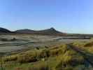
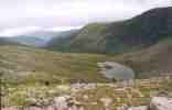
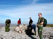
October 2009 Armadale To Strathy Point 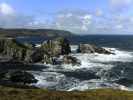 This
walk was originally scheduled for Sunday 5th October 2009 but because of a
car breakdown and worsening weather it was cancelled until the following
Sunday. We made our way to Armadale, running in and out of heavy squalls of
wind and rain. At the start of the walk a few mutinous voices were raised
about the bad weather but these were quickly quashed. We set off and at once
were hit by a heavy rain shower. Those not wearing their waterproofs quickly
changed their minds! The sun came out again and Armadale Bay looked stunning
with a wild sea running into it. Further on just before Boursa Island we
were treated to a spectacular display of water being forced up through a
borehole in the cliff by the strong wind and waves. It was hard to get the
timing right while photographing it We stopped for a bite to eat and had to
hang on to our pack lunch boxes in the gale force winds. We finished our
lunch and after walking for five minutes found a quiet sheltered valley. How
ironic! After enduring another heavy rain squall we reached Strathy
Lighthouse. So it wasn’t too bad. Only two heavy showers of rain in a day
that had not been very promising. This
walk was originally scheduled for Sunday 5th October 2009 but because of a
car breakdown and worsening weather it was cancelled until the following
Sunday. We made our way to Armadale, running in and out of heavy squalls of
wind and rain. At the start of the walk a few mutinous voices were raised
about the bad weather but these were quickly quashed. We set off and at once
were hit by a heavy rain shower. Those not wearing their waterproofs quickly
changed their minds! The sun came out again and Armadale Bay looked stunning
with a wild sea running into it. Further on just before Boursa Island we
were treated to a spectacular display of water being forced up through a
borehole in the cliff by the strong wind and waves. It was hard to get the
timing right while photographing it We stopped for a bite to eat and had to
hang on to our pack lunch boxes in the gale force winds. We finished our
lunch and after walking for five minutes found a quiet sheltered valley. How
ironic! After enduring another heavy rain squall we reached Strathy
Lighthouse. So it wasn’t too bad. Only two heavy showers of rain in a day
that had not been very promising. |
|||
|
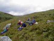
September 2009 Dunbeath Strath 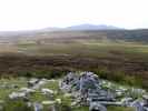 Our
walks to Foinaven in July and Ben Klibreck in August were both cancelled
because of bad weather. The trip to Slioch in September was not much better.
Low clouds and drizzle with water pouring down the burns from previous days
of heavy rain. I managed to fall in a burn and get soaked to the arse! Five
of us set out and only two made it to the top. It was such a contrast in
weather two weeks later for our walk up Dunbeath Strath. A sunny day with a
blustery wind. Our first stop was at the Broch only five minutes along the
path. It’s worth a look over the stone wall surrounding it to see the lovely
view up and down the Strath. We continued on our way following the path up
to the soldiers leap then on to the cemetery where we stopped for a tea
break. We crossed the moor which was fairly dry to the small hill of Cnoc na
maranaich with its cairns on the top. You are rewarded with a fine view of
Morven and the Scarabens to the west and the coast of Caithness to the east.
The wind turbines at Houstry were busily turning in the strong breeze. Whets
the problem some people have with them? I find them quite graceful. David
showed us the quarry where a large stone lay with the wedges still in place
for splitting it. It was amazing to realise that it had been left like that
thousands of years ago. A short walk but very interesting.....Robert
Mackenzie Our
walks to Foinaven in July and Ben Klibreck in August were both cancelled
because of bad weather. The trip to Slioch in September was not much better.
Low clouds and drizzle with water pouring down the burns from previous days
of heavy rain. I managed to fall in a burn and get soaked to the arse! Five
of us set out and only two made it to the top. It was such a contrast in
weather two weeks later for our walk up Dunbeath Strath. A sunny day with a
blustery wind. Our first stop was at the Broch only five minutes along the
path. It’s worth a look over the stone wall surrounding it to see the lovely
view up and down the Strath. We continued on our way following the path up
to the soldiers leap then on to the cemetery where we stopped for a tea
break. We crossed the moor which was fairly dry to the small hill of Cnoc na
maranaich with its cairns on the top. You are rewarded with a fine view of
Morven and the Scarabens to the west and the coast of Caithness to the east.
The wind turbines at Houstry were busily turning in the strong breeze. Whets
the problem some people have with them? I find them quite graceful. David
showed us the quarry where a large stone lay with the wedges still in place
for splitting it. It was amazing to realise that it had been left like that
thousands of years ago. A short walk but very interesting.....Robert
Mackenzie |
|||
|
February 2008 Ousdale to Berriedale 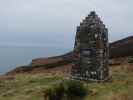 It
was a lovely morning. The temperature was 4° c but it felt warmer as there
was no wind. We parked the cars at Badbea and walked ½KM south along the A9
until we picked up the Ousdale burn. This runs down a lovely wooded strath
which gradually becomes deeper as it reaches the sea. Once we reached the
coast we walked north towards Badbea passing several old crofts before we
stopped at the monument at Badbea for lunch. After some hot tea and rolls we
set off again. We picked up the old coast road which made walking a lot
easier until we finally came in sight of the two towers (sounds like Lord of
the Rings) above Berriedale before scrambling down the hill and coming out
at the swing bridge at the shore. It
was a lovely morning. The temperature was 4° c but it felt warmer as there
was no wind. We parked the cars at Badbea and walked ½KM south along the A9
until we picked up the Ousdale burn. This runs down a lovely wooded strath
which gradually becomes deeper as it reaches the sea. Once we reached the
coast we walked north towards Badbea passing several old crofts before we
stopped at the monument at Badbea for lunch. After some hot tea and rolls we
set off again. We picked up the old coast road which made walking a lot
easier until we finally came in sight of the two towers (sounds like Lord of
the Rings) above Berriedale before scrambling down the hill and coming out
at the swing bridge at the shore. |
|||
|
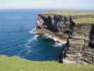
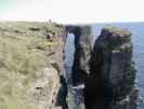
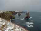
July 2007 Melvich To Sandside 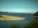 July
saw us taking a walk from Melvich to Sandside. The sky was a brilliant blue
and the sun shone all day. Further inland grey clouds hung around but the
north westerly wind kept the coast clear. July
saw us taking a walk from Melvich to Sandside. The sky was a brilliant blue
and the sun shone all day. Further inland grey clouds hung around but the
north westerly wind kept the coast clear.This is a fantastic piece of coastline with many geos, sea stacks and high cliffs. There were plenty of adult puffins, kittiwakes and fulmars to be seen but there did not seem to be a lot of juvenile birds. Everyone enjoyed their day out and some even had a touch of sunburn! Not bad for this summer. |
|||
|
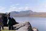
May 2007 Ben Loyal 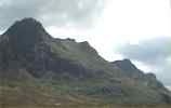 As part of the Caithness and Sutherland 2007 Walking festival Caithness
Waybaggers hosted a walk and climb to Ben Loyal. This took place on the 20th
May 2007.
We left Wick at 8.00 am in our hired mini- bus. It took just under the two
hours to get to Tongue. Here we met up with a further 10 walkers from the
walking festival making a total of 18 altogether.
We headed down to Ribigill farm and started our walk from there. There is a
good track for the first 3 kms but this peters out at Allt Lon Malmsgaig
burn. Luckily there wasn’t a lot of water flowing so we managed to step
across without any wet feet.
We stopped for a tea break at Cunside cottage before heading for the first
slopes of Ben Loyal.
The early morning cloud had started to break up so that by the time we
arrived at Sgor a Bhatain the day was sunny and clear but with a very strong
wind blowing. We admired the wonderful views over The Kyle of Tongue before
heading to An Caisteal which is the highest point at 764 metres.
We headed back down through the heathery slopes and eventually made it back
to our bus.
I think everyone was satisfied with their day including our guests, some who
had come from as far away as Preston and Glasgow.
Map As part of the Caithness and Sutherland 2007 Walking festival Caithness
Waybaggers hosted a walk and climb to Ben Loyal. This took place on the 20th
May 2007.
We left Wick at 8.00 am in our hired mini- bus. It took just under the two
hours to get to Tongue. Here we met up with a further 10 walkers from the
walking festival making a total of 18 altogether.
We headed down to Ribigill farm and started our walk from there. There is a
good track for the first 3 kms but this peters out at Allt Lon Malmsgaig
burn. Luckily there wasn’t a lot of water flowing so we managed to step
across without any wet feet.
We stopped for a tea break at Cunside cottage before heading for the first
slopes of Ben Loyal.
The early morning cloud had started to break up so that by the time we
arrived at Sgor a Bhatain the day was sunny and clear but with a very strong
wind blowing. We admired the wonderful views over The Kyle of Tongue before
heading to An Caisteal which is the highest point at 764 metres.
We headed back down through the heathery slopes and eventually made it back
to our bus.
I think everyone was satisfied with their day including our guests, some who
had come from as far away as Preston and Glasgow.
Map |
|||
|
June 2006 Morven 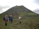 The weather forecast for Sunday 18th June was not good. Heavy rain coming in
from the west, due to arrive in Caithness about 1.00pm by the BBC weather,
or 5.00pm by the Orkney forecast. The weather forecast for Sunday 18th June was not good. Heavy rain coming in
from the west, due to arrive in Caithness about 1.00pm by the BBC weather,
or 5.00pm by the Orkney forecast.We arrived at Braemore and the day was fine and warm. Morven was clear with no low cloud covering it. We walked along the track to Corrichoich before making over the rough moor land to the bottom of Morven. There is a track up but this has become deep and worn in places and does not offer easy climbing. Its just head down and a hard slog to the top with frequent stops for a breather. I think that Morven is one of the hardest hills to climb because of it s steep slopes. We eventually reached the top with good views all round. It was not long though before the clouds rolled in and visibility was reduced to 20 feet. We left the top and headed back down through the cloud cover and over the peat lands back to Braemore. The Orkney forecast was correct with the worst of the rain staying off to 5.00pm. |
|||
|
July 2005 Beinn Stumanadh 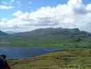 A
small hill just off the A836, 8 kms south of Tongue. The day was bright and
dry with a strong wind blowing. I heard later that the Kessock Bridge was
closed because of it. We parked the cars at the side of the road and made
for the bothy at Achnanclach 2 kms away. We walked along the north shore of
Loch Loyal where the water was being whipped up to a frenzy by the gale.
Judging by the visitor book at the bothy it was a popular place. The last
person to visit it had been only the day before. We then headed up the
gully to Sron Ruadh. Stopping for a breather we noticed four deer higher up
watching our progress before they cantered off making easy work of the steep
slope. We followed the wide horse shoe shaped ridge from Sron Ruadh round to
Beinn Stumanadh and the trig point at 527 metres. The wind at the top was
really ferocious with some gusts knocking you sideways or blowing you
backwards or forwards. It was good to get back down again into a gentler
gale. By the time we walked back past Loch Loyal I swear you could have gone
surfing on it. Should have bought that wet suit out of Lidl! A
small hill just off the A836, 8 kms south of Tongue. The day was bright and
dry with a strong wind blowing. I heard later that the Kessock Bridge was
closed because of it. We parked the cars at the side of the road and made
for the bothy at Achnanclach 2 kms away. We walked along the north shore of
Loch Loyal where the water was being whipped up to a frenzy by the gale.
Judging by the visitor book at the bothy it was a popular place. The last
person to visit it had been only the day before. We then headed up the
gully to Sron Ruadh. Stopping for a breather we noticed four deer higher up
watching our progress before they cantered off making easy work of the steep
slope. We followed the wide horse shoe shaped ridge from Sron Ruadh round to
Beinn Stumanadh and the trig point at 527 metres. The wind at the top was
really ferocious with some gusts knocking you sideways or blowing you
backwards or forwards. It was good to get back down again into a gentler
gale. By the time we walked back past Loch Loyal I swear you could have gone
surfing on it. Should have bought that wet suit out of Lidl! |
|||
|
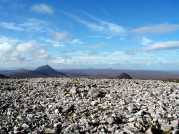
September 2004 Stac Pollaidh 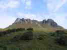 Ullapool
is a very lively town with a busy harbour, numerous bed and breakfasts and
plenty of cafes and restaurants to eat in. We wandered round the streets
looking at the various menus outside the eating establishments. My stomach
was growling with hunger by the time we found a place that suited everyone’s
taste. Fed and watered we returned to our lodgings for a good nights sleep
before facing the big hill the next day. What a perfect day it was.
The sun was shinning and it was pleasantly warm as we started up the track
opposite the car park on the Drumrunie to Achiltibuie road. Stac Pollaidh is
613 metres high and attracts 30,000 people each year. Today was no exception
with a full car park looking like Safeways/Morrisons/Sommerfield on a
Saturday morning. The hill itself is mostly red sandstone which over the
course of time had been worn down to a craggy tower with spiky pinnacles and
scree. A new path has been created round the western side of the hill while
the eastern path is repaired. Eventually a circular route will be made round
the hill. The path leads to the eastern saddle of Stac Pollaidh. Six of our
party made for the western summit which involved some scary climbing over
awkward pieces of rock. The views were brilliant on such a clear day with
most of Wester Ross bathed in the September sunshine. Report
Marie Mackenzie
Map Of Stac Pollaidh - known locally as Stack Polly Ullapool
is a very lively town with a busy harbour, numerous bed and breakfasts and
plenty of cafes and restaurants to eat in. We wandered round the streets
looking at the various menus outside the eating establishments. My stomach
was growling with hunger by the time we found a place that suited everyone’s
taste. Fed and watered we returned to our lodgings for a good nights sleep
before facing the big hill the next day. What a perfect day it was.
The sun was shinning and it was pleasantly warm as we started up the track
opposite the car park on the Drumrunie to Achiltibuie road. Stac Pollaidh is
613 metres high and attracts 30,000 people each year. Today was no exception
with a full car park looking like Safeways/Morrisons/Sommerfield on a
Saturday morning. The hill itself is mostly red sandstone which over the
course of time had been worn down to a craggy tower with spiky pinnacles and
scree. A new path has been created round the western side of the hill while
the eastern path is repaired. Eventually a circular route will be made round
the hill. The path leads to the eastern saddle of Stac Pollaidh. Six of our
party made for the western summit which involved some scary climbing over
awkward pieces of rock. The views were brilliant on such a clear day with
most of Wester Ross bathed in the September sunshine. Report
Marie Mackenzie
Map Of Stac Pollaidh - known locally as Stack Polly |
|||
|
May 2004 Ben Stack 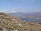 This hill lies six miles South
East of
Rhichonich in the North West of
Sutherland. We had to go the long way along the North coast as we had to
pick up one of our party in Thurso. Loch Eriboll is very beautiful but the
drive down one side and up the other is very frustrating. By the time we
reached our starting point at the shores of Loch Stack the rest of the party
was already there. They had travelled the shorter route via Lairg. Ben
Stack is 2364 ft high, 50 ft higher than Morven. The way up the South
East slopes were quite wet and boggy in places. The water was sitting in
pools unable to run of the hill due to the bare rocks only inches below the
surface of grass and earth. The day was warm and sunny and the clouds
which covered the top were gradually lifting. The scree slopes of Arkle to
the North East glistened as white as snow in the sun. Suddenly the cloud
lifted and revealed the final slope. Now I knew why it had been called Ben
Stack. It reared steeply upwards in a giant grassy mound. Two people
descending the slope looked very small and insignificant. We finally reached
the top to be greeted by an amazing site. We were standing above a sea of
clouds with only the tops of distant hills rising above them. We
lingered for a while at the top admiring the views but eventually headed
back down. It’s a long way to Wick and we had to go back round Loch Eriboll
worse luck!
Map This hill lies six miles South
East of
Rhichonich in the North West of
Sutherland. We had to go the long way along the North coast as we had to
pick up one of our party in Thurso. Loch Eriboll is very beautiful but the
drive down one side and up the other is very frustrating. By the time we
reached our starting point at the shores of Loch Stack the rest of the party
was already there. They had travelled the shorter route via Lairg. Ben
Stack is 2364 ft high, 50 ft higher than Morven. The way up the South
East slopes were quite wet and boggy in places. The water was sitting in
pools unable to run of the hill due to the bare rocks only inches below the
surface of grass and earth. The day was warm and sunny and the clouds
which covered the top were gradually lifting. The scree slopes of Arkle to
the North East glistened as white as snow in the sun. Suddenly the cloud
lifted and revealed the final slope. Now I knew why it had been called Ben
Stack. It reared steeply upwards in a giant grassy mound. Two people
descending the slope looked very small and insignificant. We finally reached
the top to be greeted by an amazing site. We were standing above a sea of
clouds with only the tops of distant hills rising above them. We
lingered for a while at the top admiring the views but eventually headed
back down. It’s a long way to Wick and we had to go back round Loch Eriboll
worse luck!
Map |
|||
|
April 2004 Ben Hutig 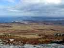 Some Waybagger walks attract
a large attendance. April’s walk to Ben Hutig wasn’t to be one of them. Four
brave souls gathered in the car park at Safeway, Wick and scanned the area
anxiously for more bodies. It was not to be. We set off for our destination
in one car. Ben Hutig sits 4-5 miles north west of Tongue. It rises
408 metres above the bleak moorland. The weather forecast for the day was a
front coming in from the west with squally showers. We parked the car across
the bridge at Lubinvullin and trudged up the good track to Loch na h-Uamhachd.
No sign of rain yet as we cut across the boggy ground to gain the lower
slopes of Ben Hutig. We reached the top quickly and the views were
spectacular. The island of Eilean Nan Ron with its ruined cottages and
Rabbit Islands lay in Tongue Bay. Ben Loyal with its jagged teeth of tops
rose in the east and Ben Hope further west had its crown hidden in clouds.
We walked along the ridge of Ben Hutig passing the small hidden lochans on
its sides. The wind had turned cold so we left the top to find shelter in a
small valley beside a burn. We stopped for our lunch and had the invasion of
the caterpillars! Hundreds of them had hatched out in the warmth and shelter
and were immediately investigating these strange beings who had invaded
their domain. Better than ticks though! We headed back to the car
through some very boggy ground, which Ian managed to fall into. A good day
out which the rest of you lazy Waybaggers managed to miss. Some Waybagger walks attract
a large attendance. April’s walk to Ben Hutig wasn’t to be one of them. Four
brave souls gathered in the car park at Safeway, Wick and scanned the area
anxiously for more bodies. It was not to be. We set off for our destination
in one car. Ben Hutig sits 4-5 miles north west of Tongue. It rises
408 metres above the bleak moorland. The weather forecast for the day was a
front coming in from the west with squally showers. We parked the car across
the bridge at Lubinvullin and trudged up the good track to Loch na h-Uamhachd.
No sign of rain yet as we cut across the boggy ground to gain the lower
slopes of Ben Hutig. We reached the top quickly and the views were
spectacular. The island of Eilean Nan Ron with its ruined cottages and
Rabbit Islands lay in Tongue Bay. Ben Loyal with its jagged teeth of tops
rose in the east and Ben Hope further west had its crown hidden in clouds.
We walked along the ridge of Ben Hutig passing the small hidden lochans on
its sides. The wind had turned cold so we left the top to find shelter in a
small valley beside a burn. We stopped for our lunch and had the invasion of
the caterpillars! Hundreds of them had hatched out in the warmth and shelter
and were immediately investigating these strange beings who had invaded
their domain. Better than ticks though! We headed back to the car
through some very boggy ground, which Ian managed to fall into. A good day
out which the rest of you lazy Waybaggers managed to miss. |
|||
|
February 2004 Braemore 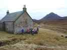 Sunday 15th February was
mild and calm. After a bit of confusion over cars we eventually set off for
Braemore. The walk started at the telephone box there. It must be one of the
last old red ones left. Pity it doesn’t work. We made up the track to Glutt
Lodge but took a left after 31 kms down the track to Gobernusgeach bothy.
The wind by this time had turned quite cold and everyone was walking along
with a drip at their nose. The bothy is kept in find condition and is
clean and tidy inside. We stopped there for a tea break and some sandwiches
before crossing the nearby swing bridge over Berriedale water and headed
home wards again. The day head turned warmer again as we made down the
river to Carrichoich cottage. One fit person even climbed Carn Mor and
Maiden Pap on the way back to Braemore. The rest of us were happy just to
stay on the low ground and eventually make our way back to Braemore. Sunday 15th February was
mild and calm. After a bit of confusion over cars we eventually set off for
Braemore. The walk started at the telephone box there. It must be one of the
last old red ones left. Pity it doesn’t work. We made up the track to Glutt
Lodge but took a left after 31 kms down the track to Gobernusgeach bothy.
The wind by this time had turned quite cold and everyone was walking along
with a drip at their nose. The bothy is kept in find condition and is
clean and tidy inside. We stopped there for a tea break and some sandwiches
before crossing the nearby swing bridge over Berriedale water and headed
home wards again. The day head turned warmer again as we made down the
river to Carrichoich cottage. One fit person even climbed Carn Mor and
Maiden Pap on the way back to Braemore. The rest of us were happy just to
stay on the low ground and eventually make our way back to Braemore. |
|||
|
September 2003 |
|||
|
August 2003 Beinn Alligin 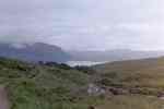 The Secretary Robert
Mackenzie when he draws up the programme for our walks fits in an away day.
This years away day was to climb Beinn Alligin. The mountain, a Munro, is
situated in Wester Ross at the head of Loch Torridon. Two cars full of
Waybaggers set out on a Saturday afternoon and made our way to Torridon. We
arrived at the Torridon Youth Hostel which Robert had booked for us in
advance and got ourselves settled in. That evening we availed ourselves at a
local hostelry and climbed the hill at least 3 or 4 times over a few drinks.
When we set out for Beinn Alligin the sky was on the ground but the hostel
supervisor said that the forecast was good. We started from the car park at
the bridge over Abhainn Coire Mhic Nobuil burn, and followed the well
defined path towards Na Rathanan (The Horns of Alligin). However, when we
got near them it was decided either because of time or fear that we would go
round rather than over them. This meant following a path with a nearly
vertical drop on the left. From then on it became clear that the Waybaggers
had never encountered this type of hill before but onward and upward. After
much struggling by this old Waybagger we reached the first summit Sgurr Mhor
and by then the weather had cleared and spectacular views were worth the
pain. Having had our second wind we headed down and up towards Tom na
Gruagaich, the second Munro on this ridge. The descent into Coir' nan
Laogh was not started until the usual Waybagger plan a and b had been sorted
out, eventually we made our way back to the car park from where we set off
on the road home tired but content. The Secretary Robert
Mackenzie when he draws up the programme for our walks fits in an away day.
This years away day was to climb Beinn Alligin. The mountain, a Munro, is
situated in Wester Ross at the head of Loch Torridon. Two cars full of
Waybaggers set out on a Saturday afternoon and made our way to Torridon. We
arrived at the Torridon Youth Hostel which Robert had booked for us in
advance and got ourselves settled in. That evening we availed ourselves at a
local hostelry and climbed the hill at least 3 or 4 times over a few drinks.
When we set out for Beinn Alligin the sky was on the ground but the hostel
supervisor said that the forecast was good. We started from the car park at
the bridge over Abhainn Coire Mhic Nobuil burn, and followed the well
defined path towards Na Rathanan (The Horns of Alligin). However, when we
got near them it was decided either because of time or fear that we would go
round rather than over them. This meant following a path with a nearly
vertical drop on the left. From then on it became clear that the Waybaggers
had never encountered this type of hill before but onward and upward. After
much struggling by this old Waybagger we reached the first summit Sgurr Mhor
and by then the weather had cleared and spectacular views were worth the
pain. Having had our second wind we headed down and up towards Tom na
Gruagaich, the second Munro on this ridge. The descent into Coir' nan
Laogh was not started until the usual Waybagger plan a and b had been sorted
out, eventually we made our way back to the car park from where we set off
on the road home tired but content. |
|||
|
July 2003 |
|||
|
July 2003 |
|||
|
June 2003 |
|||
|
May 2003 Wick to Whaligoe  The wind was blowing in our
faces as we started our walk at the end of the Trinkie road. We were making
for Whaligoe along the coast about nine kilometres away as the crow flies.
It was quite chilly at first but we soon warmed up with a bit of exertion.
The Brig O’Trams just south of the Castle of Old Wick looked quite
spectacular. The bird-nesting season had started and every available cliff
ledge which faced south-east was packed with birds. Guillemots were in the
majority but we also saw razor bills and fulmars. This is a great coastal
walk with amazing cliff scenery and masses of bird life all the way along
it. The wind was blowing in our
faces as we started our walk at the end of the Trinkie road. We were making
for Whaligoe along the coast about nine kilometres away as the crow flies.
It was quite chilly at first but we soon warmed up with a bit of exertion.
The Brig O’Trams just south of the Castle of Old Wick looked quite
spectacular. The bird-nesting season had started and every available cliff
ledge which faced south-east was packed with birds. Guillemots were in the
majority but we also saw razor bills and fulmars. This is a great coastal
walk with amazing cliff scenery and masses of bird life all the way along
it. |
|||
|
April 2003 |
|||
|
February 2003 |
|||
|
December 2002 |
|||
|
October 2002 |
|||
|
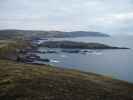
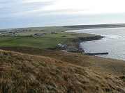
September 2002 Strath Brora - West Of Golspie, Sutherland 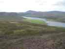 September
took us to Strath Brora west of Golspie. We parked the cars at Doll beside a
ford that crosses the River Brora. A path lead west through woods eventually
taking us out on to open moorland to Duchary Ridge where the remains of a
hillfort can be seen. The path continues on to Coire Aghaisgeig where it
disappeared into the moor. Heading north eastwards we eventually saw the
remains of Carrol Broch in the distance. It really stands out from the
surrounding countryside. It is still in quite good condition compared to
some of the brochs which dot the Caithness & Sutherland landscape. We made
for Carrol Rock which although it is not high is very steep. It was
worth it though for the stunning views of Loch Brora and beautiful
Gordonbush Estate. It must be great to have money! We made our way back
along Loch Brora to the cars.
The Gordonbush
Estate extends to 13,354
acres. September
took us to Strath Brora west of Golspie. We parked the cars at Doll beside a
ford that crosses the River Brora. A path lead west through woods eventually
taking us out on to open moorland to Duchary Ridge where the remains of a
hillfort can be seen. The path continues on to Coire Aghaisgeig where it
disappeared into the moor. Heading north eastwards we eventually saw the
remains of Carrol Broch in the distance. It really stands out from the
surrounding countryside. It is still in quite good condition compared to
some of the brochs which dot the Caithness & Sutherland landscape. We made
for Carrol Rock which although it is not high is very steep. It was
worth it though for the stunning views of Loch Brora and beautiful
Gordonbush Estate. It must be great to have money! We made our way back
along Loch Brora to the cars.
The Gordonbush
Estate extends to 13,354
acres. |
|||
|
August 2002 |
|||
|
July 2002 Sandwood Bay 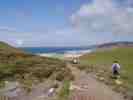 Start:
Car Park at Blairmore 4-mile track into Sandwood Bay Start:
Car Park at Blairmore 4-mile track into Sandwood BayIt was a long drive from Wick but it was very worthwhile as the views were fantastic. We were lucky as the sun was shinning – it was a bit blowy but that kept any midges away. Best of all when we all sat down for our tea later on at a local hotel – someone phoned home and said it had been raining in Wick most of the day. Excellent day out |
|||
| 2
June 2002 Loch Hope And Arnaboll 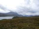 A
full minibus of walkers set off on a damp morning from Wick.
On the way west the rain was heavier and there were foggy patches.
By the time we reached our starting point at the head of the River
Hope seven miles past Tongue it was clearer and drier. We followed
the track in on the edge of Loch Hope and stopped at Arnaboll
cottage A
full minibus of walkers set off on a damp morning from Wick.
On the way west the rain was heavier and there were foggy patches.
By the time we reached our starting point at the head of the River
Hope seven miles past Tongue it was clearer and drier. We followed
the track in on the edge of Loch Hope and stopped at Arnaboll
cottage |
|||
| May
2002 Halkirk To Thurso Down The Thurso River 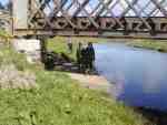 It
was a nice sunny day although a cold wind was blowing. We put the boots on
at Braal Castle and headed off down Thurso River. We saw a variety of wild
life. Mallard ducks with their young broods of ducklings. Either Sand
Martins or House Martins (we weren’t sure which) zipping up and down the
river like small fighter aeroplanes, and a Yellow Hammer. It
was a nice sunny day although a cold wind was blowing. We put the boots on
at Braal Castle and headed off down Thurso River. We saw a variety of wild
life. Mallard ducks with their young broods of ducklings. Either Sand
Martins or House Martins (we weren’t sure which) zipping up and down the
river like small fighter aeroplanes, and a Yellow Hammer. |
|||
|
April 2002 Garvault to climb Ben Griam Mor (590m) 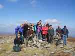 Fourteen
of us set off from Garvault to climb Ben Griam Mor (590m). It was a fine
morning although the top of Ben Griam Mor could not be seen for low cloud.
As we made our ascent the cloud lifted and we could then see what we were
heading for. Fourteen
of us set off from Garvault to climb Ben Griam Mor (590m). It was a fine
morning although the top of Ben Griam Mor could not be seen for low cloud.
As we made our ascent the cloud lifted and we could then see what we were
heading for. |
|||
| 2
March 2002 Crofts of Ben-a-chielt to Rumster  Six intrepid
souls set off on a pretty threatening morning from Forse House heading to
the Niandt to Corr old road ( now is mostly overgrown by whins) which we
followed up to the Corr. On route we stopped for a wee while to have a look
at the hut circles and broughs Six intrepid
souls set off on a pretty threatening morning from Forse House heading to
the Niandt to Corr old road ( now is mostly overgrown by whins) which we
followed up to the Corr. On route we stopped for a wee while to have a look
at the hut circles and broughs
|
|||
| 3
February 2002 Thurso East To Dunnet 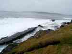 Our
Walk on 3rd February 2002 was planned to be from Halkirk to
Thurso down Thurso River. Because of the wet winter we have had it was
decided to give this a miss as the river was flooded in places. Instead we
decided to walk from Thurso East along the coast by Murkle and Castletown
finally ending at the Pavilion at Dunnet beach. Our
Walk on 3rd February 2002 was planned to be from Halkirk to
Thurso down Thurso River. Because of the wet winter we have had it was
decided to give this a miss as the river was flooded in places. Instead we
decided to walk from Thurso East along the coast by Murkle and Castletown
finally ending at the Pavilion at Dunnet beach. |
|||
| 6
January 2002 Berriedale Water Walk 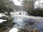 The
first walk of 2002 for the Caithness Waybaggers was up Berriedale Water on
Sunday 6th January 2002. The
first walk of 2002 for the Caithness Waybaggers was up Berriedale Water on
Sunday 6th January 2002.The Braemore road was still quite icy and required careful driving. We left a car at the disused quarry and then drove back to Berriedale where we were to start our walk. |
|||