|
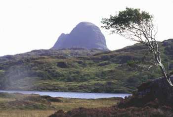
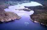
1 November 04 Geopark status has been awarded to the area which encompasses parts of Wester Ross and the whole of North West Sutherland on the basis of its outstanding geology and landscape, the strength of its partnership approach to sustainable economic development and its existing geological interpretation facilities. Stretching from Coigach in Wester Ross to Cape Wrath and Loch Eriboll in the north, this 2000 square km area takes in some of the finest mountain and coastal landscapes in Britain and contains a wealth of classic geological localities. It includes the iconic mountains of Suilven, Arkle and Stac Pollaidh, the pristine beaches of Sandwood and Balnakiel, and dramatic coastal cliffs such as those at Cape Wrath, mainland Scotland's most north-westerly point.
Within the area are Assynt-Coigach and North West Sutherland National Scenic Areas, two National Nature Reserves, 54 Geological Conservation Review sites, geological sites of Special Scientific Importance, Special Protection Areas and Special Areas of Conservation. There are also a significant number of historical and archaeological sites, including scheduled monuments and listed buildings. Officials from The Highland Council and the British Geological Survey who have been working closely with the local communities to put together the bid, travelled to Sicily to give a presentation at the annual meeting of the European Geopark Network and were present when the announcement was made. Convener of The Highland Council, Councillor Alison Magee said: "This is wonderful news. The rich natural heritage of the North West Highlands is recognised not only in the high number of designations we have but also in the number of geology students from all over the world who visit the area as part of their studies and the rising number of tourists who specifically come to walk the hills and admire the beauty of the scenery. From the early evidence of human habitation in Scotland, through to Norse settlements, the Lordship of the Isles to the Clearances, crofting and recent land reform, the human story can be traced in the unique landscape we have that dates back over 9,000 years." Dr Maarten Krabbendam, Project Leader of the British Geological Surveys Moine Thrust Project, said: "Scotland's first Geopark contains some of the most important and diverse geological and geomorphological features in Britain. It is internationally renowned for a variety of features including Britain's oldest rocks and a famous structure known as the Moine Thrust. This type of geological fault is more clearly visible here than almost anywhere else on the planet. The area has also been key in the historical development of geological science. Famous geologists of the 19th century such as Roderick Murchison, Archibald Geikie, Benjamin Peach and John Horne, cut their geological teeth on the rocks of Sutherland. Research using modern survey techniques into the same rocks, structures and geomorphological features in the area continues today. What makes the area so attractive is the very strong link between geology and landscape since every rock type has its own unique landscape." Unlike a National Park, the award of Geopark status does not place any restrictions on the management of the land so no new planning or land use policy will be introduced. Geopark status is for a period of three years after which membership will be reviewed. The Highland Council's Sutherland Area Chairman, Councillor Francis Keith said: "This news will have a tremendous benefit to the area and will spark new and exciting initiatives. We will now be able to market and promote ourselves internationally with the prestige honour of being Scotland's first designated European Geopark and I am confident that this will significantly enhance new funding opportunities for individual projects. It is now our responsibility to protect and promote the geological heritage and to use our natural and cultural heritage to encourage sustainable economic development." A Geopark Action Group has been established to oversee the running and policy direction of the Geopark. This is made up from representatives from The Highland Council, British Geological Survey, Scottish Natural Heritage and the local enterprise company together with a range of local stakeholders whose aim is to raise awareness of the North West Highlands Geopark locally, nationally and internationally. Lesley Cranna, Area Manager for SNH's North Highland Area said: "I am delighted that SNH's new National Nature Reserve at Knockan Crag and our rock route trail have made a significant contribution to the successful geopark bid. We are looking forward to working with the wide range of local groups and agencies involved in the geopark to raise awareness of our geological heritage, to promote its sensitive management and to encourage more people to come to the area to enjoy it." Included within the Geopark is the community of Assynt which is concentrated in small crofting communities, the majority of which lie along the rugged coastline, either to the north or south of the village and fishing port of Lochinver. Chairman of Assynt Community Council Ron Evans said: "It is very rewarding to learn that considerable efforts by national organisations and community groups, co-ordinated by The Highland Council, have resulted in the granting of Geopark status to the North-West of Scotland. Organisations in Assynt will continue their endeavours to promote local economic regeneration knowing that international recognition of the area as a special place will be invaluable." Chris Rix, Assynt Field Centre, Inchnadamph said: "The Field Centre is already used as a base for field studies by students from both UK & overseas universities, and the area's status as a European Geopark will help attract an even wider mix of professional & amateur geological enthusiasts to the north west. It presents an excellent opportunity for us to promote our wonderful landscape and natural heritage." Neil Campbell from Loch Assynt Lodge Estate said: "The area is unique in lending itself to the whole spectrum of geological study, from beginners to experts. No where is such complex geology better exposed, allowing the layman to understand the forces of nature and yet complex enough to continue to puzzle the professional geologists." There will be an official opening of the Geopark next year and a Geopark Officer will shortly be appointed to identify and develop community-led projects. Established in June 2000, the European Geopark Network now consists of 17 members in 9 European countries. The network has no formal connection with the European Union. In February 2004 the European Geoparks Network was formally integrated into the UNESCO-endorsed Global Geoparks Network. For more details go to www.europeangeopark.org UNESCO is the United Nations Educational, Scientific and Cultural Organisation. In the UK the following areas have
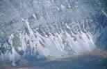
Geopark status; Since securing Geopark status these areas have seen considerable benefit through increased nature-based tourism. Within the boundary of the North West Highland Geopark lies the internationally important Moine Thrust Zone. Along this line are craggy peaks of Torridonian sandstone and Cambrian quartzite shaped by glaciers during the Quaternary ice ages. Between the mountains are secluded glens some of which are floored by the largest areas of limestone in Scotland. Caves in the limestone have provided fossil evidence of Pleistocene ice-age fauna and reindeer, polar bears and wolves. For further details please go to http://earth.leeds.ac.uk/assyntgeology/ |
Assynt's Geology
Who's Who Assynt Geology History Nature Reserve Views Of The Area
Official Bodies British Geomorphological Research Group Geological Conservation Review
General Links
|