|
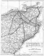
ROADS AND TRACKS THROUGH LOCAL HISTORY Part 2 - Unrecorded Ways George Watson It is clear from the scanty records that the early road markers were merely improving short sections of a well developed network of tracks. A partial reconstruction of this early road system will be attempted using historical events, surviving remnants of track, local topography and placenames. Since the selection and interpretation of such material is very subjective the conclusions must be treated with due caution. These old roads may not have been very grand. Joseph Mitchell the famous civil engineer described them as 'bridle paths' but they were the main highways of their day and should not he dismissed too lightly. A good example of such a road, ran southwest from Thurso towards Kinbrace. It was never 'lined out' for it passed through a sparsely populated region which could not muster an adequate statute labour force. The first step towards improvement was never taken and, therefore all subsequent development was inhibited. Nevertheless the route continued to be used and eventually became popular with drovers, who appreciated its easy going, ample grazing and the fact that it bypassed the tolls being levied on the improved roads. This late use ensured that the way was shown on maps from 1812 onwards. Although it is no longer continuous, sections of it are still used by farmers, gamekeepers and sportsmen and the line from Thurso to Rumsdale can be traced with reasonable certainty. Additional confirmation of the route is given by a marker stone called Clach Seasaimh and the place name Ca na Catanach. In the more cultivated parts of the County, traces of old tracks can be found on marginal land which has escaped the plough. It is very much a matter of opinion how these sporadic remains should be joined in any reconstructon. Fortunately, Joseph Mitchell provided a useful clue when he said of Orkney roads,". . . the roads had been made in various parts (1 presume by statute labour) very much along the old foot and bridle paths, which had been widened, with all their steep acclivities and sinuousities. . .". A similar pattern can be found in Caithness where traces of the older tacks are often found close to later roads. To the south of Lybster, for example, Telford's redundant bridge lies upstream from the modern road bridge, while downstream is an older bridge with an earlier ford underneath. Further downstream, above the harbour, the oldest track of all, zigzags down the hillside behind Inver House, to cross the burn on the shingle beach which once filled the inlet. This track was sketched by Telford about 1790, during a preliminary inspection of the bay before any harbour development had taken place. Here then, within a short distance are four or five crossings of the Reisgill. Similar groups and sequences of roads can be identified at the Ord, Dunbeath, Latheronwheel and Latheron. When this skein of roads reaches Bruan, some of the older tracks are a more direct route northwards through the Warehouse hills, over Tannoch moor to cross the river Wick near Haster at Mary Ford and Red Ford. (Red in this case may well be the Gaelic 'rathaid' meaning 'of the road'.) Mary Ford and Red Ford lying so close together, must be seen as sequential development of the same basic line, rather like the multiple bridges at Lybster, and indicates that the route was in use over a considerable period. The intertwining of roads of different ages, along the same general route is due to geographical restraints which are not always obvious in an open landscape like Caithness, but bogs, lochs and unbridged watercourses can be just as constrictive as mountain glens and passes. The older tracks tend to keep to the high ground where the going is firmer and the streams smaller. The coastal tracks, which have to traverse fully developed streams usually do so where the water spreads out over the beach. The problem of fording a small burn is well illustrated In an anecdote told by David Stephen about the Rev. Mr. Mill of Canisbay and the Rev. Mr. Smith of Bower as they tried to cross the burn of Durran: "Mr. Smith tucked up his limbs and urged his horse forward, arriving at the other side he turned round and said, 'Come away, Mr. Mill, has your faith failed ye?' Whether from lack of faith or want of courage Mr. Mill did not attempt the stream, and the water rising, he found himself surrounded by the element, the only dry place being the remains of a turf dyke, on which he walked all night to keep himself from being benumbed with cold." It is hardly surprising that safe fords became named landmarks, still to be found on modern maps. Soft ground could be just as troublesome, as the Mey letters of 30th April 1742 shows: "After parting with you yesterday, my black horse was so misfortunate as to bugg himself immediately below Thurdestaff. In the struggle to get out, he burst some vessel within which has occasioned his death this day. . . . . " The well drained banks of streams were often the best way over wet moorland, and 'burn following' con be demonstrated in many places; with tracks on both sides of the larger watercourse. The concept of roads of different periods, following the some topographical restraints is the basis of the reconstruction shown in Fig. 1. The older historical roads were used as the skeleton and a broad ribbon of ground was taken on either side of them. Traces of the older tracks are more likely to be found within the corridors so produced. Fresh insights into local events can be obtained when known historical incidents are considered within the proposed road network. When Campbell of Glenorchy came north to take over the earldom, he was confronted by the defending force of Caithnessians near Stirkoke . The day being far spent and his men tired by their forced march from Braemore, Campbell wisely retreated to a safe encampment in the Yarrows hills, the Caithness men retired to Wick for the night. An early start the next morning saw GIenorchy make an unopposed crossing of the river Wick. From his position on the north bank he would see the local men advancing from the town and no doubt selected the steep sided spit of land at the junction of the burn of Altimarlach and the river, as the best defensive position. In a complete reversal of the previous evening, it was the Caithness troops who arrived exhausted by their dash from Wick. Click To Enlarge
Further north, still on the same line between 'h' and 'i', In Viking times (c. 980) Two battles are recorded on Skitten Moor. On both occasions, the forces from the south attempted to outflank the defensive line of the Loch and river of Wester, only to find themselves trapped by the soft ground of 'Skida Myre', now the Moss of Wester. Further to the west, on the track between 'i' and 'r' are two significantly named fords; the first 'The Ford of the Meetings' is probably the junction of two of the old tracks, and the second called, 'The Ford of the Roads' carried the combined tracks over the Hobbiegill Burn. The 'oute i, r, q, p, o' can be it illustrated by a story preserved by Thomas Sinclair in his book 'The Gunns' . "Paul Macintyre had right to get from Caithness yearly nine score kine, as long as he came for them personally. lt happened at last that he was busy erecting and fortifying a castle at Creich, in Sutherland. He sent his son Gillespie and Murdo Rivach Mackenzie, an outlaw and brave warrior, with a strong party of men, to take up the custom cows, but the Caithnessians assembled at Spittal Hill, and put themselves under the command of Burb, afterwards Budge of Toftingall. They took up their position at the south corner of the east end of Loch Watten, extending themselves to the steep banks of the river below Achingale. The banks protected their right flank as Loch Watten did their left, and moreover they had the advantage of the higher ground. Here they waited the approach of GiIlespee and Murdo Rivach, who were driving a herd of cattle from the low lands. On arriving, the strangers made a furious attack on the centre of Burb's position, and succeeded, but only for a time, in pushing back. The Caithness men. The fight was furious and the slain many. At last Gillespie and Murdo were overpowered by numbers, and both fell in action. The remains of Gillespie were taken home, and there is a poem extant which relates that when crossing Helmsdale river, which was in flood, the force of the current carried away the corpse and those bearing it, and all were lost. Murdo Rivach's body was buried where he fell, and the mark of his grave is still to be seen. His head was being carried home, and while the company were passing the top of the Ord, the road then on the very edge of the cliffs, a fight took place between two of those bearing the head, and both, together with their ghastly burden, tumbled over the rocks, a hundred feet high, and were dashed to pieces. Murdo Rivach Mackenzie's two handed sword remained in the possession of the Budges of Toftingall till the year 1688, when it was given to Kenneth Mackenzie of Seaforth." Sinclair at another point, gives a slightly different version of the same story. "He (Paul Macintyre) had a son Murdo Reoch, a stout and hardy captain, who while he was taking up the custom cows was killed by the men of Caithness at Spittal Hill. Murdo's sons then retreating were drowned at Helmsdale." This tale has many ancient elements and can be dated between 1350 and 1372 when Paul McTyre appears in historical records. It seems likely that the cattle were being brought from the Freswick/Buchollie area or from Ackergill where at that time the Earl of Ross, a patron of McTyre, had lands. It is plain from this story that there were recognised routes and that the local men knew just where to lay their ambush for the best result. Two other well known events can be related to show the use of these roads In medieval times. In 1158 Thoriorn Klerk waylaid and killed Earl Rognvald at Forsie. Forsie is now rather off the beaten track but lies on the old route from Thurso to Kinbrace, 'k' to 'n'. The Orkneyinga Saga tells that Earl Rognvald and Earl Harald were going deer hunting in Caithness, as they had done for several years. When they arrived at Thurso they were warned that Thorbiorn Klerk was waiting for a chance to attack them. However they set out and the following morning as Earl Rognvald was greeting the farmer at Forsie, Thorbiorn burst from the farmhouse and the Earl was fatally wounded in the ensuing fight. Clearly Thorbiorn had been waiting for some time beside the track which he expected the hunters to take. The southern branch of the moorland road, 'n' to 'o', was probably used in 1290 by the envoys of King Edward I of England as they Journeyed north to confirm the death of the Maid of Norway at St. Margaret's Hope. They stayed overnight on the 2nd October at Helmsdale, probably at St. John's Hospital which occupied part of the present-day cemetery; the fo1lowing night they were at 'Hospital', usually assumed to be St. Magnus at Spittal, and on the 4th October they lodged In Wick. This itinerary is difficult to explain if a modern road map is used, but is more understandable when the moorland road 'n' to 'o' is identified. The envoys were heading for Orkney and were uncertain whether their quickest route was via Thurso, Huna or Wick so they took a sensible compromise and called in at Spittal, where the latest shipping news would be available from travellers arriving at this major crossroad from all directions. It is also possible that the envoys had been forced up the Helmsdale valley by the river in spate, which made fording near the mouth too dangerous. The positions of some castles are related to the road network. Knockinnon Castle at junction 'd' is an obvious example. From its vantage point on Cnoc Heara it not only commands the coast road but the Causewaymire route as well. To the north Keiss Castle occupies a similar position. Brawl Castle is built on a site with few natural advantages. It was built to control the main ford across the Thurso river and the fact that it uses the meagre defence of the river on its southern side shows that it was from that direction that trouble was expected. Exactly the same remarks could be repeated for Loch More Castle, which also seems to have controlled a crossing place for a later date (c. 1700) the stones from the ruined castle are said to have been used to build a bridge at this spot. (The present bridge is of 'Parliamentary' design and cannot be much earlier than 1840). The remains of a small fortalice, called Coroner Gunn's Garden, which can still be found on Strath Farm, Watten, also overlooks the ford on Strath Burn. Perhaps the most surprising and interesting result arises when the many chapel sites are plotted on the reconstructed road map. If we look in detail at the road from Rumsdale to Spittal, 'n' to 'o', then as the road crosses Rumsdale Water at St Ciaran's it divides into Thurso and Spittal branches. The next sizeable burn to be crossed is Allt a'Mhuilinn at Dalnawillan where there is a burial ground of uncertain age. The track follows the north bank of the river Thurso to Dalnaha ( Dale or Meadow of the Ford) and within a short distance, on the south side of Loch More, is St. Bridget's at Achscoriclate. Continuing along the south side of the Ioch and river, the next ford called Ath nan Leac (Ford of the Slabs) lies between Strathmore Lodge and the small cemetery at Acharynie. The line of the track runs on to Westerdale, where St. Trostans, near Balantsionnach, lies a short distance below the road-bridge. Some maps show a second un-named chapel near Dale House, immediately opposite St. Trostans. There are no further water hazards from Dale, over Achanarras Hill to Spittal. The pattern which emerges is that there is a known chapel site, or a graveyard which could be a secondary development of an earlier chapel, at or close to each of the larger fords. This theory will be explored in part 3. REFERENCES.
CORRECTION TO PART 1. It was said in Part 1 that "Post Offices had been established at Kirkwall, Thurso and Wick about 1750 ......." The recently published Mey letters show that post was being delivered to Thurso as early as 16th August 1706. This article originally appeared in The Caithness Field Club bulletin - April 1986 |